IMAGES TAKEN NEAR TO
Holmwood View, LEEDS, LS6 4NG
Introduction
This page details the photographs taken nearby to Holmwood View, LS6 4NG by members of the Geograph project.
The Geograph project started in 2005 with the aim of publishing, organising and preserving representative images for every square kilometre of Great Britain, Ireland and the Isle of Man.

There are currently over 7.5m images from over14,400 individuals and you can help contribute to the project by visiting https://www.geograph.org.uk
Image Map
Images are licensed for reuse under creativecommons.org/licenses/by-sa/2.0
Notes
- Clicking on the map will re-center to the selected point.
- The higher the marker number, the further away the image location is from the centre of the postcode.
Image Listing (60 Images Found)
Images are licensed for reuse under creativecommons.org/licenses/by-sa/2.0
Image
Details
Distance
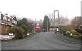
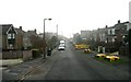
6
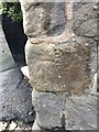
Benchmark Myrtle Pub, Meanwood
Benchmark description https://www.bench-marks.org.uk/bm135516
Image: © OfficeOfPudseyBMs
Taken: 12 Nov 2020
0.05 miles
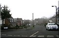
10
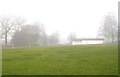
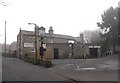
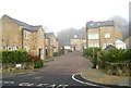
Meanwood Cricket Club - Parkside Road
Mist stopped play!
Image: © Betty Longbottom
Taken: 27 Jan 2009
0.09 miles