IMAGES TAKEN NEAR TO
Grunberg Road, LS6 3FJ
Introduction
This page details the photographs taken nearby to Grunberg Road, LS6 3FJ by members of the Geograph project.
The Geograph project started in 2005 with the aim of publishing, organising and preserving representative images for every square kilometre of Great Britain, Ireland and the Isle of Man.

There are currently over 7.5m images from over14,400 individuals and you can help contribute to the project by visiting https://www.geograph.org.uk
Image Map
Images are licensed for reuse under creativecommons.org/licenses/by-sa/2.0
Notes
- Clicking on the map will re-center to the selected point.
- The higher the marker number, the further away the image location is from the centre of the postcode.
Image Listing (286 Images Found)
Images are licensed for reuse under creativecommons.org/licenses/by-sa/2.0
Image
Details
Distance
1
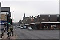
Otley Road Headingley
Viewed south at junction North Ln/Wood Ln.
Same view many years ago, tram tracks and overhead power.
http://www.flickr.com/photos/yorkshirerose/1167304599/in/photostream
Image: © Rick Carn
Taken: 23 Mar 2012
0.01 miles
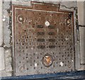
2
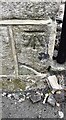
Benchmark on #35A Otley Road on south side of Bennett Road
Ordnance survey cut mark benchmark levelled at 85.762m above Newlyn Datum verified 1957
Image: © Roger Templeman
Taken: 6 Jun 2023
0.03 miles
3
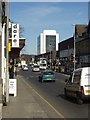
Otley Road, Headingley
Looking north towards the traffic lights at the junction with North Lane and Wood Lane. The tall office block is part of the Arndale Centre. For a view of the same stretch of road in 1937 see the Leodis website, where you will see a Number 2 tram - the Number 2 bus still operates on this route 70 years later. http://www.leodis.org/display.aspx?id=2002527_72520083
Image: © Rich Tea
Taken: 22 Mar 2006
0.03 miles
4
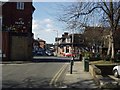
Wood Lane, Otley Road and North Lane
Looking west along Wood Lane towards the traffic lights where Otley Road crosses, and North Lane beyond.
Image: © Rich Tea
Taken: 22 Mar 2006
0.03 miles

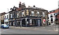
6
Bennett Road face of #35 Otley Road Oasis Properties
There is an Ordnance Survey benchmark Image on the right hand side of the doorway
Image: © Roger Templeman
Taken: 6 Jun 2023
0.03 miles
7
Air Raid Shelter
WW2 Shelter cover/access, Otley Road Headingley.
On footpath below left window of Boots Chemists.
Visible Google Streetview.
Image: © Rick Carn
Taken: 14 Dec 2011
0.04 miles
8
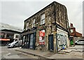
Shops at junction of Bennett Road and Otley Road
Image: © Luke Shaw
Taken: 6 Jun 2023
0.04 miles
9
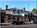
Former Overseers' Office, North Lane, Headingley
An unusual style of building, dated 1914, bearing the arms of the City of Leeds, and perhaps surprisingly not listed. It is now used by an estate agent.
Image: © Stephen Craven
Taken: 17 Sep 2016
0.04 miles
10
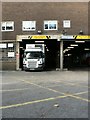
Delivery bays, Arndale Centre, Headingley
Beside Wood Lane.
Image: © Rich Tea
Taken: 7 Nov 2006
0.05 miles