IMAGES TAKEN NEAR TO
Queenswood Heights, LEEDS, LS6 3EE
Introduction
This page details the photographs taken nearby to Queenswood Heights, LS6 3EE by members of the Geograph project.
The Geograph project started in 2005 with the aim of publishing, organising and preserving representative images for every square kilometre of Great Britain, Ireland and the Isle of Man.

There are currently over 7.5m images from over14,400 individuals and you can help contribute to the project by visiting https://www.geograph.org.uk
Image Map
Images are licensed for reuse under creativecommons.org/licenses/by-sa/2.0
Notes
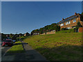
- Clicking on the map will re-center to the selected point.
- The higher the marker number, the further away the image location is from the centre of the postcode.
Image Listing (173 Images Found)
Images are licensed for reuse under creativecommons.org/licenses/by-sa/2.0
Image
Details
Distance
1
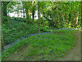
Bluebells in Batcliffe Wood
Batcliffe Wood, in its present form, is best described as a linear park: a narrow belt of woodland with a few public paths along its length or joining from the side. An interpretation board on site explains that it was once part of the monastic New Grange farm, later known as Kirkstall Grange, which in the 19th century was owned at different times by the textile magnate John Marshall and the financier William Beckett. The estate now forms the bulk of the Beckett University campus and Beckett Park. A 'friends' group has helped to improve the woodland in recent years.
Image: © Stephen Craven
Taken: 7 May 2020
0.04 miles
2
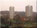
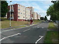
Queenswood Court and Queenswood Heights
These blocks ('Court' left, and 'Heights' right) are located on Queenswood Drive in Headingley, and viewed here from Headingley station. They were built in 1964/65 (source: http://www.skyscrapernews.com/buildings.php?id=1594 ) and are still managed by Leeds City Council.
Image: © Stephen Craven
Taken: 15 Dec 2016
0.05 miles
3
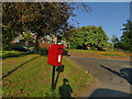
Postbox on Queenswood Drive
Near the junction with Queenswood Rise.
Image: © Stephen Craven
Taken: 7 May 2020
0.07 miles
4
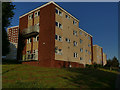
Flats on Queenswood Drive
One of several low-rise (4-storey) blocks. There are also a couple of tower blocks, one of which can be seen in the background.
Image: © Stephen Craven
Taken: 7 May 2020
0.07 miles
5
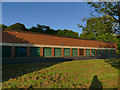
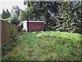
Garages for Queenswood Heights
These garages are clearly associated with the adjacent tower block dating from 1965 Image
Image: © Stephen Craven
Taken: 7 May 2020
0.07 miles
6
Flats, Queenswood Drive, Headingley, Leeds
Image: © Humphrey Bolton
Taken: 9 Jun 2018
0.08 miles
8
Foxcroft Green
A short dead-end road of fairly modern housing.
Image: © Stephen Craven
Taken: 29 Sep 2023
0.09 miles
9
Queenswood Road
The road has a wide verge on this eastern side, with the houses set well back up a slope.
Image: © Stephen Craven
Taken: 7 May 2020
0.09 miles
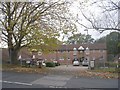
10
Substation on Foxcroft Mount
A single storey brick building set well back from the road.
Image: © Stephen Craven
Taken: 29 Sep 2023
0.09 miles