IMAGES TAKEN NEAR TO
Back Broomfield Crescent, LEEDS, LS6 3BP
Introduction
This page details the photographs taken nearby to Back Broomfield Crescent, LS6 3BP by members of the Geograph project.
The Geograph project started in 2005 with the aim of publishing, organising and preserving representative images for every square kilometre of Great Britain, Ireland and the Isle of Man.

There are currently over 7.5m images from over14,400 individuals and you can help contribute to the project by visiting https://www.geograph.org.uk
Image Map
Images are licensed for reuse under creativecommons.org/licenses/by-sa/2.0
Notes
- Clicking on the map will re-center to the selected point.
- The higher the marker number, the further away the image location is from the centre of the postcode.
Image Listing (299 Images Found)
Images are licensed for reuse under creativecommons.org/licenses/by-sa/2.0
Image
Details
Distance
1
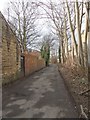
Back Broomfield Crescent - Chapel Lane
Image: © Betty Longbottom
Taken: 17 Feb 2012
0.01 miles
2
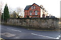
Leeds Zoological and Botanical Gardens, Headingley
Apart from the Bear Pit on Cardigan Rd, few clues remain that these ever existed.
The wall on Spring Road was one of the entrances, the house a later build when the park was sold off for development.
Today, Cardigan Rd cuts through the middle of the former gardens.
Image: © Rick Carn
Taken: 15 Dec 2011
0.02 miles
3
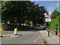
Bainbrigge Road, Headingley
This is the western end at its junction with Cardigan Road. This part of Leeds gets particularly congested with traffic in the peak hours, which is why the road is closed to traffic in the evening peak to avoid "rat running".
Image: © Stephen Craven
Taken: 12 Jul 2020
0.04 miles
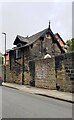
4
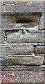
Benchmark on outbuilding of #84 Cardigan Road on east side of Chapel Lane
Ordnance Survey cut mark levelled at 71.787m above Newlyn Datum verified 1957
Image: © Roger Templeman
Taken: 6 Jun 2023
0.04 miles
5
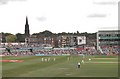
Headingley Cricket Ground
Headingley Cricket Ground during the Pakistan/England test match. St Michael's and All Angels church in the distance.
Image: © Darren Haddock
Taken: 5 Aug 2006
0.04 miles
6
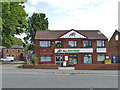
"All Rounder", St Michael's Lane, Headingley
Situated close to the Headingley cricket stadium, this is a sports equipment shop.
Image: © Stephen Craven
Taken: 12 Jul 2020
0.05 miles
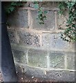
7
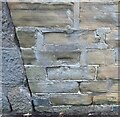
Headingley, outbuilding to 84 Cardigan Road
The benchmark is cut into the west facing wall of an outbuilding to 84 Cardigan Road. The cutmark is worn and weathered.
Image: © Mel Towler
Taken: 13 Nov 2022
0.05 miles
8
Headingley, outbuilding to 84 Cardigan Road
There is a benchmark cut into the west facing wall of an outbuilding to 84 Cardigan Road. The cutmark is worn and weathered.
Image: © Mel Towler
Taken: 13 Nov 2022
0.05 miles
9
Outbuilding on east side of Chapel Lane at rear of #84 Cardigan Road
There is an Ordnance Survey benchmark Image on the far corner of the outbuilding to the right of the lamppost.
Image: © Roger Templeman
Taken: 6 Jun 2023
0.05 miles
10
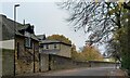
Headingley, Cardigan Road
The benchmark is cut into the lowest course of stone on the east side of Cardigan Road, and to the south of the junction with Spring Road.
Image: © Mel Towler
Taken: 13 Nov 2022
0.05 miles