IMAGES TAKEN NEAR TO
St. Michaels Crescent, LEEDS, LS6 3AL
Introduction
This page details the photographs taken nearby to St. Michaels Crescent, LS6 3AL by members of the Geograph project.
The Geograph project started in 2005 with the aim of publishing, organising and preserving representative images for every square kilometre of Great Britain, Ireland and the Isle of Man.

There are currently over 7.5m images from over14,400 individuals and you can help contribute to the project by visiting https://www.geograph.org.uk
Image Map
Images are licensed for reuse under creativecommons.org/licenses/by-sa/2.0
Notes
- Clicking on the map will re-center to the selected point.
- The higher the marker number, the further away the image location is from the centre of the postcode.
Image Listing (303 Images Found)
Images are licensed for reuse under creativecommons.org/licenses/by-sa/2.0
Image
Details
Distance
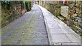
1
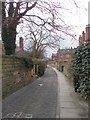
Chapel Lane - off St Michael's Lane
Image: © Betty Longbottom
Taken: 17 Feb 2012
0.01 miles
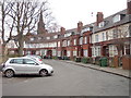
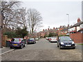
2
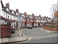
St Michael's Crescent - St Michael's Lane
Image: © Betty Longbottom
Taken: 17 Feb 2012
0.01 miles
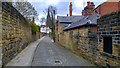
6
St Michael's Crescent - St Michael's Lane
Image: © Betty Longbottom
Taken: 17 Feb 2012
0.03 miles
7
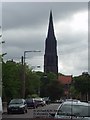
St Michael and All Angels, Headingley Lane, Headingley, Leeds
Seen looking east along St Michaels Road
Image: © Rich Tea
Taken: Unknown
0.05 miles
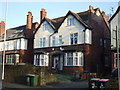
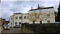
9
St Michael's Grove - St Michael's Lane
Image: © Betty Longbottom
Taken: 17 Feb 2012
0.05 miles
10
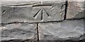
Benchmark on roadside wall fronting #9 St Michael's Villas
Ordnance Survey cut mark benchmark levelled at 77.276m above Newlyn Datum verified 1957
Image: © Roger Templeman
Taken: 6 Jun 2023
0.05 miles