IMAGES TAKEN NEAR TO
Johnston Street, LEEDS, LS6 2NQ
Introduction
This page details the photographs taken nearby to Johnston Street, LS6 2NQ by members of the Geograph project.
The Geograph project started in 2005 with the aim of publishing, organising and preserving representative images for every square kilometre of Great Britain, Ireland and the Isle of Man.

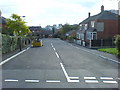
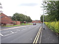
There are currently over 7.5m images from over14,400 individuals and you can help contribute to the project by visiting https://www.geograph.org.uk
Image Map
Images are licensed for reuse under creativecommons.org/licenses/by-sa/2.0
Notes
- Clicking on the map will re-center to the selected point.
- The higher the marker number, the further away the image location is from the centre of the postcode.
Image Listing (243 Images Found)
Images are licensed for reuse under creativecommons.org/licenses/by-sa/2.0
Image
Details
Distance
1
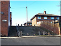
Steps on Elm Street, Leeds
Elm Street was once a through road, but housing redevelopment around the upper part of it have resulted in reducing the gradient, with a consequent drop in the middle.
Image: © Stephen Craven
Taken: 2 Apr 2019
0.05 miles
2
Ganton Place, off Elm Street, Leeds
This was formerly Ganton Place when it was traditional terraced houses either side; now widened, renamed and with a more modern take on terraced housing.
Image: © Stephen Craven
Taken: 2 Apr 2019
0.05 miles
3
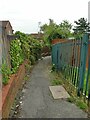
Footpath to Johnston Street
The path links Hartley Crescent Recreation Ground to the residential area around Johnston Street.
Image: © Stephen Craven
Taken: 23 Jul 2021
0.06 miles
4
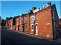
Beulah Street, Leeds
Typical of back-to-back houses in the former industrial suburbs of Leeds. Many have been demolished over the years but enough remain, often with converted lofts to increase the available floor space in what were originally "one up, one down" houses.
Image: © Stephen Craven
Taken: 2 Apr 2019
0.06 miles
5
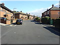
Marian Road, Woodhouse Carr, Leeds.
Looking SE from Johnston Street.
Image: © Steve Partridge
Taken: 28 Sep 2006
0.07 miles
6
Johnston Street, Meanwood Carr, Leeds.
Looking NE from the junction with Marian Road.
Image: © Steve Partridge
Taken: 28 Sep 2006
0.07 miles
7
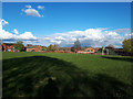
Hartley Crescent Public Open Space (2)
Football pitches and a children's playground occupy the eastern part of the space.
Image: © Stephen Craven
Taken: 2 Apr 2019
0.07 miles
9
Melville Road - viewed from Woodhouse Street
Image: © Betty Longbottom
Taken: 18 Aug 2012
0.07 miles
10
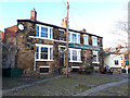
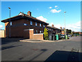
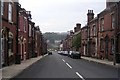
The Chemic Tavern, Johnston Street, Leeds
Friends in the Leeds folk scene rate this highly as a live music venue.
Image: © Stephen Craven
Taken: 2 Apr 2019
0.08 miles