IMAGES TAKEN NEAR TO
Hartley Gardens, LEEDS, LS6 2ND
Introduction
This page details the photographs taken nearby to Hartley Gardens, LS6 2ND by members of the Geograph project.
The Geograph project started in 2005 with the aim of publishing, organising and preserving representative images for every square kilometre of Great Britain, Ireland and the Isle of Man.

There are currently over 7.5m images from over14,400 individuals and you can help contribute to the project by visiting https://www.geograph.org.uk
Image Map
Images are licensed for reuse under creativecommons.org/licenses/by-sa/2.0
Notes
- Clicking on the map will re-center to the selected point.
- The higher the marker number, the further away the image location is from the centre of the postcode.
Image Listing (182 Images Found)
Images are licensed for reuse under creativecommons.org/licenses/by-sa/2.0
Image
Details
Distance
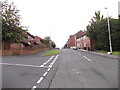
2
Hartley Avenue - viewed from Melville Place
Image: © Betty Longbottom
Taken: 18 Aug 2012
0.02 miles
3
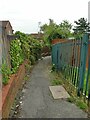
Footpath to Johnston Street
The path links Hartley Crescent Recreation Ground to the residential area around Johnston Street.
Image: © Stephen Craven
Taken: 23 Jul 2021
0.03 miles
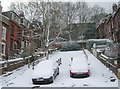
5
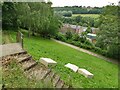
Access to Woodhouse Ridge
These steps from Melville Place give access to a traffic-free woodland walk of about a mile to Grove Lane, whence one can pick up the Meanwood Valley Trail all the way to Golden Acre Park. Just a pity about the flytipped mattresses.
Image: © Stephen Craven
Taken: 23 Jul 2021
0.04 miles
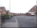
6
Melville Place - viewed from Johnston Street
Image: © Betty Longbottom
Taken: 18 Aug 2012
0.04 miles
8
Melville Place - viewed from Johnston Street
Image: © Betty Longbottom
Taken: 18 Aug 2012
0.06 miles
9
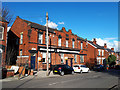
Building on Hartley Avenue
The building bears the date 1902. It is not listed, nor identified on old maps. It looks as if it may have been a shop (perhaps Co-Operative?) but is now converted to housing.
Image: © Stephen Craven
Taken: 2 Apr 2019
0.06 miles
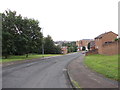
10
Wharfedale Place - Wharfedale Avenue
Image: © Betty Longbottom
Taken: 2 Feb 2009
0.06 miles