IMAGES TAKEN NEAR TO
Quarry Mount Street, LEEDS, LS6 2JF
Introduction
This page details the photographs taken nearby to Quarry Mount Street, LS6 2JF by members of the Geograph project.
The Geograph project started in 2005 with the aim of publishing, organising and preserving representative images for every square kilometre of Great Britain, Ireland and the Isle of Man.

There are currently over 7.5m images from over14,400 individuals and you can help contribute to the project by visiting https://www.geograph.org.uk
Image Map
Images are licensed for reuse under creativecommons.org/licenses/by-sa/2.0
Notes
- Clicking on the map will re-center to the selected point.
- The higher the marker number, the further away the image location is from the centre of the postcode.
Image Listing (254 Images Found)
Images are licensed for reuse under creativecommons.org/licenses/by-sa/2.0
Image
Details
Distance
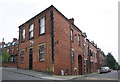
2
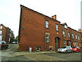
Former Delph Lane Co-Op store (1)
It was only the name "The Old Co-Op" on an iron gate that drew my attention to this building. This view of the side along Providence Road shows an arched entrance, presumably for deliveries. The foundation stone Image is on the left hand corner.
Image: © Stephen Craven
Taken: 12 May 2017
0.02 miles
3
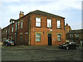
Former Delph Lane Co-Op store (2)
It was only the name "The Old Co-Op" on an iron gate that drew my attention to this building. This view is of the frontage to Delph Lane, but see also Image
Image: © Stephen Craven
Taken: 12 May 2017
0.02 miles
4
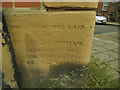
Former Delph Lane Co-Op store (3) - foundation stone
For context, see Image The soft sandstone (most likely from the local quarries that gave the street its name) is already very eroded. All I can make out of the inscription is:
This stone was laid
by
..... Earnshaw
..... of the
..... Committee
..... 1885
One Isaac Earnshaw was a director of the Leeds Industrial Co-Operative Society, and president in 1889 (source: http://www.gerald-massey.org.uk/holyoake/c_leeds_co-op_4.htm ). I have heard from a distant relative who has records showing that that Isaac laid the Foundation Stone on 15th January 1876, several years before he became President. The date of 1885 is therefore something of a mystery.
Image: © Stephen Craven
Taken: 12 May 2017
0.02 miles

7
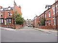
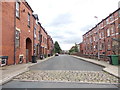
Inglewood Terrace or Delph Lane #2
Google say Delph Lane, but is it Inglewood Terrace?
Image: © Ian S
Taken: 2 Oct 2010
0.03 miles
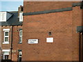
8
Benchmark on #22 Delph Lane
Ordnance Survey cut mark benchmark described on the Bench Mark Database at http://www.bench-marks.org.uk/bm76422
Image: © Roger Templeman
Taken: 10 Jun 2016
0.03 miles
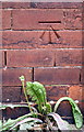
9
#22 Delph Lane at Providence Road junction
There is an OS benchmark Image on the near corner, right hand face, of the former Co-op, left of a grey cabinet above a dandelion
Image: © Roger Templeman
Taken: 10 Jun 2016
0.03 miles
10
Leeds, 22 Delph Lane
The benchmark is cut into the south facing wall of the property, and is to the left of the grey metal street furniture.
Image: © Mel Towler
Taken: 8 Mar 2023
0.03 miles