IMAGES TAKEN NEAR TO
Royal Park Mount, LEEDS, LS6 1HL
Introduction
This page details the photographs taken nearby to Royal Park Mount, LS6 1HL by members of the Geograph project.
The Geograph project started in 2005 with the aim of publishing, organising and preserving representative images for every square kilometre of Great Britain, Ireland and the Isle of Man.

There are currently over 7.5m images from over14,400 individuals and you can help contribute to the project by visiting https://www.geograph.org.uk
Image Map
Images are licensed for reuse under creativecommons.org/licenses/by-sa/2.0
Notes
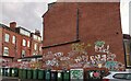
- Clicking on the map will re-center to the selected point.
- The higher the marker number, the further away the image location is from the centre of the postcode.
Image Listing (218 Images Found)
Images are licensed for reuse under creativecommons.org/licenses/by-sa/2.0
Image
Details
Distance
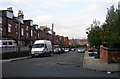
1
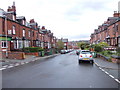
Brudenell Street - Royal Park Grove
Image: © Betty Longbottom
Taken: 28 Apr 2012
0.02 miles
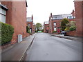
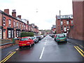
2
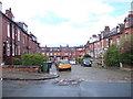
Royal Park Mount - Royal Park Grove
Image: © Betty Longbottom
Taken: 28 Apr 2012
0.02 miles
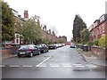
4
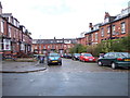
Royal Park Mount - Royal Park Grove
Image: © Betty Longbottom
Taken: 28 Apr 2012
0.03 miles
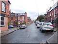
6
Brudenell Street - Royal Park Grove
Image: © Betty Longbottom
Taken: 28 Apr 2012
0.04 miles
7
Royal Park Avenue - Brudenell Street
Image: © Betty Longbottom
Taken: 28 Apr 2012
0.04 miles
8
Royal Park Grove - Royal Park Road
Image: © Betty Longbottom
Taken: 28 Apr 2012
0.04 miles
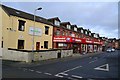
9
Headingley, 30 Brudenell Mount
According to the OS benchmark database there is a cutmark on the gable end of the property. Telecommunications' cabinets and wheelie bins obscure any view!
Image: © Mel Towler
Taken: 6 Jan 2023
0.05 miles
10
Brudenell Grove - Royal Park Road
Image: © Betty Longbottom
Taken: 28 Apr 2012
0.05 miles