IMAGES TAKEN NEAR TO
Brudenell Road, LEEDS, LS6 1HA
Introduction
This page details the photographs taken nearby to Brudenell Road, LS6 1HA by members of the Geograph project.
The Geograph project started in 2005 with the aim of publishing, organising and preserving representative images for every square kilometre of Great Britain, Ireland and the Isle of Man.

There are currently over 7.5m images from over14,400 individuals and you can help contribute to the project by visiting https://www.geograph.org.uk
Image Map
Images are licensed for reuse under creativecommons.org/licenses/by-sa/2.0
Notes
- Clicking on the map will re-center to the selected point.
- The higher the marker number, the further away the image location is from the centre of the postcode.
Image Listing (226 Images Found)
Images are licensed for reuse under creativecommons.org/licenses/by-sa/2.0
Image
Details
Distance
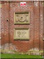
1
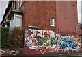
Headingley, 41 Brudenell Road
The benchmark is cut into the gable end of the property.
Image: © Mel Towler
Taken: 6 Jan 2023
0.01 miles
2
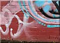
Headingley, 41 Brudenell Road
There is a benchmark cut into the centre of the gable end of the property, amidst the wall art.
Image: © Mel Towler
Taken: 6 Jan 2023
0.01 miles
3
Stone Carvings - The Leeds Industrial Co-Operative Society Building 1892
Intricate stone carvings to the [N] Wrangthorn Place side of LICS 1892 building.
Image: © Rick Carn
Taken: 30 Nov 2011
0.02 miles
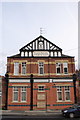
4
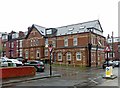
Former Cooperative store, Brudenell Grove
Dated 1892. Converted into apartments around the turn of the 21st century. The sculpted stone panels https://www.geograph.org.uk/photo/5742315 in the left hand gable were moved from the arched panels when windows were inserted as part of the conversion. The building is not listed but the conversion is sympathetic to the historical nature of it.
Image: © Alan Murray-Rust
Taken: 12 Apr 2018
0.02 miles
5
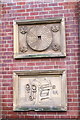
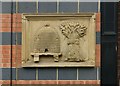
Former Cooperative store, Brudenell Grove
Decorative panels depicting a millstone and a later roller flour mill, reinstalled here when the building was converted. See https://www.geograph.org.uk/photo/5742313 .
Image: © Alan Murray-Rust
Taken: 12 Apr 2018
0.02 miles
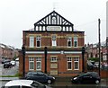
6
LICS Brudenell Grove
Now converted to flats, the stone carvings to the front and sides were retained.
This is off the beaten track just down from Hyde Park.
Image: © Rick Carn
Taken: 30 Nov 2011
0.02 miles
7
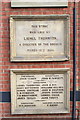
March 19th 1892 Leeds Ind Co-Op Historic Tablets
On Brudenell Grove, Hyde Park. Linked to photos of the ornate stone carvings listed here.
On reflection and from memory I'm sure that years ago there were 4 of those, so one missing.
Image: © Rick Carn
Taken: 30 Nov 2011
0.02 miles
8
Former Cooperative store, Brudenell Grove
Dated 1892. Converted into apartments around the turn of the 21st century. The building is not listed but the conversion is sympathetic to the historical nature of it.
Image: © Alan Murray-Rust
Taken: 12 Apr 2018
0.02 miles
9
Stone Carvings - The Leeds Industrial Co-Operative Society Building 1892
Beautiful stone carvings on the [S] Brudenell Avenue side of this historic building, a short walk from the Hyde Park Picture House.
The building and, presumably, the original shop faces east onto Brudenell Grove (see other posts here).
Further carvings adorn the [N] Wrangthorn Place side.
Image: © Rick Carn
Taken: 30 Nov 2011
0.03 miles
10
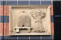
Former Cooperative store, Brudenell Grove
Decorative panel depicting a beehive and a wheatsheaf, traditional symbols of the co-operative movement, reinstalled here when the building was converted. See http://www.geograph.org.uk/photo/5742313 .
Image: © Alan Murray-Rust
Taken: 12 Apr 2018
0.03 miles