IMAGES TAKEN NEAR TO
Victoria Road, LEEDS, LS6 1FU
Introduction
This page details the photographs taken nearby to Victoria Road, LS6 1FU by members of the Geograph project.
The Geograph project started in 2005 with the aim of publishing, organising and preserving representative images for every square kilometre of Great Britain, Ireland and the Isle of Man.

There are currently over 7.5m images from over14,400 individuals and you can help contribute to the project by visiting https://www.geograph.org.uk
Image Map
Images are licensed for reuse under creativecommons.org/licenses/by-sa/2.0
Notes
- Clicking on the map will re-center to the selected point.
- The higher the marker number, the further away the image location is from the centre of the postcode.
Image Listing (235 Images Found)
Images are licensed for reuse under creativecommons.org/licenses/by-sa/2.0
Image
Details
Distance
1
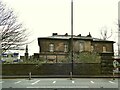
Rose Court - development halted
The building here is the former Leeds High School for Girls, seen better in Image It dates from 1842, "probably by John Clark" according to Historic England who list it grade II (List entry 1256012). It was supposed to be converted as part of a housing development, but that has presumably been put on hold by anticipation of a recession following the Covid-19 pandemic.
Image: © Stephen Craven
Taken: 27 Dec 2020
0.00 miles
2

Cycle lane on Headingley Lane
Despite the name, Headingley Lane is a busy urban A-road (A660). It's also a key cycling route for students between the Headingley and Hyde Park residential areas and the city centre. In the Covid-19 pandemic of 2020 these 'wands' were introduced to provide an additional degree of protection for cyclists.
Image: © Stephen Craven
Taken: 27 Dec 2020
0.02 miles
3
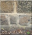
Headingley, Headingley Lane
The benchmark is cut into the roadside wall on the north side of the lane, and to the west of the junction with Grosvenor Road.
Image: © Mel Towler
Taken: 8 Mar 2023
0.02 miles
4
Headingley, Headingley Lane
There is a benchmark cut into the roadside wall on the north side of the lane, and to the west of the junction with Grosvenor Road.
Image: © Mel Towler
Taken: 8 Mar 2023
0.02 miles
5

Speed camera on Headingley Lane
The speed limit is 30mph.
Image: © Stephen Craven
Taken: 27 Dec 2020
0.03 miles
6

Fast car on Headingley Lane
The registration - WAT8T - doesn't appear on a DVLA check. Draw your own conclusions.
Image: © Stephen Craven
Taken: 27 Dec 2020
0.04 miles

8

Backs of houses on Regent Park Terrace
With a particularly large three-storey house at the end of the terrace.
Image: © Stephen Craven
Taken: 27 Dec 2020
0.05 miles
9
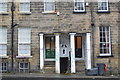
Victoria Road, Hyde Park
A photo detail of two doorways with their white painted columns on this row of what may be Victorian terraces to the west of Ebberston Road. Anyone for a scary movie!
Image: © Bobby Clegg
Taken: 31 Dec 2013
0.05 miles
10
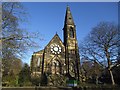
The Ashwood Centre, Headingley Lane
Originally the Headingley Hill Congregational Church (later United Reformed), built 1864 by Cuthbert Brodrick. It is listed grade 2 (list entry 1255982) and when the listing was reviewed in 1996 it was said to be converted to offices, but by 2015 was in religious use again by the City Church.
Image: © Stephen Craven
Taken: 23 Dec 2015
0.06 miles