IMAGES TAKEN NEAR TO
The Cricketers, LEEDS, LS5 3RL
Introduction
This page details the photographs taken nearby to The Cricketers, LS5 3RL by members of the Geograph project.
The Geograph project started in 2005 with the aim of publishing, organising and preserving representative images for every square kilometre of Great Britain, Ireland and the Isle of Man.

There are currently over 7.5m images from over14,400 individuals and you can help contribute to the project by visiting https://www.geograph.org.uk
Image Map
Images are licensed for reuse under creativecommons.org/licenses/by-sa/2.0
Notes
- Clicking on the map will re-center to the selected point.
- The higher the marker number, the further away the image location is from the centre of the postcode.
Image Listing (327 Images Found)
Images are licensed for reuse under creativecommons.org/licenses/by-sa/2.0
Image
Details
Distance
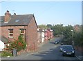
1

The Cricketers, Kirkstall Lane - western end
This housing development consists of three small blocks at the eastern end and one larger one at the western end, seen here. They occupy a linear site, about 200m long on the south side of Kirkstall Lane.
Image: © Stephen Craven
Taken: 7 Apr 2020
0.00 miles


6
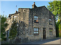
Kirkstall Cottage, Kirkstall Lane
The building also bears the name "St John's Place" and is marked as such on older maps. Two back-to-back houses may have been combined into one here, with a central door replacing the one on the splayed corner. Note the carving at high level on the corner (a lion's head, probably brought here from elsewhere). See Image for a view from further away.
Image: © Stephen Craven
Taken: 7 May 2020
0.03 miles
7
#1 St John's Place, Kirkstall Lane
There is an Ordnance Survey benchmark Image on the front of the house at its right-hand corner, and a 1856 date stone above the door.
Image: © Roger Templeman
Taken: 25 Mar 2023
0.03 miles
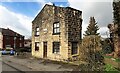
8
St John's Place, Kirkstall Lane
The name, and the date 1856, are on this side of the building in the middle of the picture. The houses behind it are on Vicarage Terrace. But the nearby church is St Stephen's, not St John's, and the vicarage is not, and never was, on this road, so the names are somewhat misleading.
Image: © Stephen Craven
Taken: 7 Apr 2020
0.03 miles
9
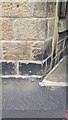
Ordnance Survey Cut Mark
This can be found on the wall of a private dwelling in Kirkstall Lane.
For more detail see : http://www.bench-marks.org.uk/bm68689
Image: © Peter Wood
Taken: 2 Jul 2015
0.03 miles
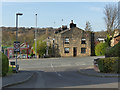
10

The Cricketers, Kirkstall Lane - car park
Some of the apartments have their own ground floor garage, but this car park on sloping land at the western end of the site serves others.
Image: © Stephen Craven
Taken: 7 Apr 2020
0.03 miles