IMAGES TAKEN NEAR TO
Victoria Park Avenue, LEEDS, LS5 3DG
Introduction
This page details the photographs taken nearby to Victoria Park Avenue, LS5 3DG by members of the Geograph project.
The Geograph project started in 2005 with the aim of publishing, organising and preserving representative images for every square kilometre of Great Britain, Ireland and the Isle of Man.

There are currently over 7.5m images from over14,400 individuals and you can help contribute to the project by visiting https://www.geograph.org.uk
Image Map
Images are licensed for reuse under creativecommons.org/licenses/by-sa/2.0
Notes
- Clicking on the map will re-center to the selected point.
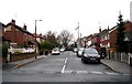
- The higher the marker number, the further away the image location is from the centre of the postcode.
Image Listing (394 Images Found)
Images are licensed for reuse under creativecommons.org/licenses/by-sa/2.0
Image
Details
Distance
5
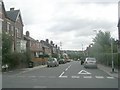
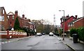
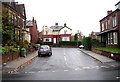
Victoria Park Avenue - viewed from Kirkstall Avenue
Image: © Betty Longbottom
Taken: 8 Aug 2011
0.04 miles
6
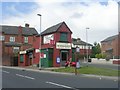
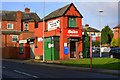
H & A C Binns Newsagents - Raynville Road
Image: © Betty Longbottom
Taken: 8 Aug 2011
0.04 miles
7
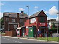
Newsagents on Raynville Road
Approaching this building down the road it appeared derelict but in fact it is still open. See also Image There is a bus stop outside.
Image: © Stephen Craven
Taken: 31 Jul 2015
0.04 miles
8
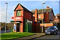
Field Funeral Services, Raynville Road, Bramley
The funeral directors opened in 2019 after renovating this wedge-shaped building formerly occupied by Binns newsagent Image
Image: © Stephen Craven
Taken: 16 Aug 2019
0.04 miles
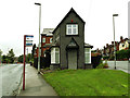
10
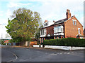
The top of Abbey Avenue
This pair of late 19th or early 20th century houses is older and larger than most of the housing in the area - they first appear on the 1908 map along with a few other properties nearby.
Image: © Stephen Craven
Taken: 4 May 2020
0.05 miles