IMAGES TAKEN NEAR TO
Abbey View, LEEDS, LS5 3DE
Introduction
This page details the photographs taken nearby to Abbey View, LS5 3DE by members of the Geograph project.
The Geograph project started in 2005 with the aim of publishing, organising and preserving representative images for every square kilometre of Great Britain, Ireland and the Isle of Man.

There are currently over 7.5m images from over14,400 individuals and you can help contribute to the project by visiting https://www.geograph.org.uk
Image Map
Images are licensed for reuse under creativecommons.org/licenses/by-sa/2.0
Notes
- Clicking on the map will re-center to the selected point.
- The higher the marker number, the further away the image location is from the centre of the postcode.
Image Listing (418 Images Found)
Images are licensed for reuse under creativecommons.org/licenses/by-sa/2.0
Image
Details
Distance
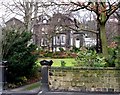
1
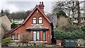
#50 Morris Lane
There is an Ordnance Survey benchmark Image on the brick and stone road end of the boundary wall on right hand side of the house
Image: © Roger Templeman
Taken: 25 Mar 2023
0.02 miles
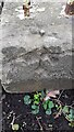
2
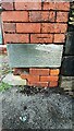
Benchmark on road end of SE side boundary wall of #50 Morris Lane
Ordnance Survey cut mark benchmark levelled at 59.442m above Newlyn Datum verified 1957
Image: © Roger Templeman
Taken: 25 Mar 2023
0.03 miles
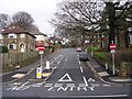
3
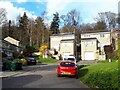
Abbey Gorse, Kirkstall
An unusual name for a road, which in this instance is a dead-end residential street off Morris Lane.
Image: © Stephen Craven
Taken: 9 Apr 2021
0.03 miles
4
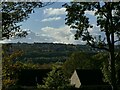
View across the Aire valley from Morris Wood
The two structures on the skyline are St Peter's church in Bramley and the transmitter mast on Beecroft Hill.
Image: © Stephen Craven
Taken: 30 Oct 2021
0.03 miles
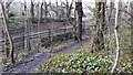
7
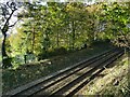
Railway below Morris Wood
The line occupies a shallow cutting along the hillside.
Image: © Stephen Craven
Taken: 30 Oct 2021
0.04 miles
8
Benchmark on wall on SW side of Morris Lane opposite #54
Ordnance Survey rivet benchmark levelled at 59.235m above Newlyn Datum verified 1957
Image: © Roger Templeman
Taken: 25 Mar 2023
0.05 miles
9
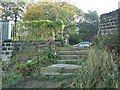
Steps to Morris Lane
From the eastern corner of the grounds of Abbey House Museum.
Image: © Rich Tea
Taken: 7 Nov 2006
0.05 miles
10
View over railway from Morris Wood
Ordnance Survey documents describe a benchmark levelled at 80.665m above Newlyn Datum which was verified in 1957 on the parapet of a bridge which crossed the railway here. There is no sign of the bridge now.
Image: © Roger Templeman
Taken: 25 Mar 2023
0.05 miles