IMAGES TAKEN NEAR TO
Eden Crescent, LEEDS, LS4 2TR
Introduction
This page details the photographs taken nearby to Eden Crescent, LS4 2TR by members of the Geograph project.
The Geograph project started in 2005 with the aim of publishing, organising and preserving representative images for every square kilometre of Great Britain, Ireland and the Isle of Man.

There are currently over 7.5m images from over14,400 individuals and you can help contribute to the project by visiting https://www.geograph.org.uk
Image Map
Images are licensed for reuse under creativecommons.org/licenses/by-sa/2.0
Notes
- Clicking on the map will re-center to the selected point.
- The higher the marker number, the further away the image location is from the centre of the postcode.
Image Listing (267 Images Found)
Images are licensed for reuse under creativecommons.org/licenses/by-sa/2.0
Image
Details
Distance
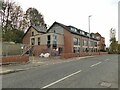
1
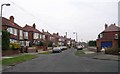
Apartments, Kirkstall Lane, Headingley
New apartments, nearly finished, on the north side of Kirkstall Lane between the Queenswood Road junction and the station.
Image: © Rich Tea
Taken: 11 Apr 2006
0.02 miles
2
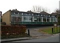
Paxton Horticultural Society - Kirkstall Lane
Image: © Betty Longbottom
Taken: 26 Nov 2007
0.02 miles
3
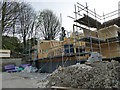
Building site, Kirkstall Lane
Planning permission had been granted for 12 apartments on the site.
Image: © Stephen Craven
Taken: 7 Apr 2020
0.04 miles
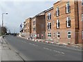
4
New flats on Kirkstall Lane
These appear to be practically complete, and there were people looking round what may have been a show apartment. See Image for an earlier stage of construction.
Image: © Stephen Craven
Taken: 7 Nov 2020
0.05 miles
6
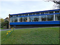
The Paxton Horticultural Society, Kirkstall Lane
A charitable organisation for gardeners, occupying a 1960s building in Headingley. See their website for more history: https://sites.google.com/site/paxtonhorticulturalsocietycouk/
Ordinary daffodils were the only flowers in evidence on this occasion.
Image: © Stephen Craven
Taken: 7 Apr 2020
0.06 miles
7
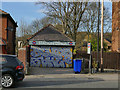
Station Diner, Kirkstall Lane
The sandwich shop has changed its name since 2011, see Image
Image: © Stephen Craven
Taken: 7 Apr 2020
0.07 miles
8
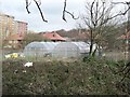
Plastic tunnels on allotments, Headingley
Looking across the railway cutting to the allotments on the north side, which have several plastic tunnels on them. Queenswood Drive in the background.
Image: © Rich Tea
Taken: 11 Apr 2006
0.07 miles
9
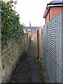
Footpath between Kirkstall Lane and Headingley Station
This footpath runs behind the buildings on Kirkstall Lane. The spire of St Stephen's church above the buildings.
Image: © Rich Tea
Taken: 11 Apr 2006
0.07 miles
10
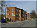
Modern flats on Kirkstall Lane
Two three-storey blocks of flats.
Image: © Stephen Craven
Taken: 7 Apr 2020
0.07 miles