IMAGES TAKEN NEAR TO
Willow Approach, LEEDS, LS4 2HE
Introduction
This page details the photographs taken nearby to Willow Approach, LS4 2HE by members of the Geograph project.
The Geograph project started in 2005 with the aim of publishing, organising and preserving representative images for every square kilometre of Great Britain, Ireland and the Isle of Man.

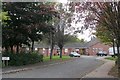
There are currently over 7.5m images from over14,400 individuals and you can help contribute to the project by visiting https://www.geograph.org.uk
Image Map
Images are licensed for reuse under creativecommons.org/licenses/by-sa/2.0
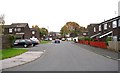
Notes
- Clicking on the map will re-center to the selected point.
- The higher the marker number, the further away the image location is from the centre of the postcode.
Image Listing (316 Images Found)
Images are licensed for reuse under creativecommons.org/licenses/by-sa/2.0
Image
Details
Distance
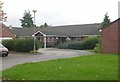
1
Burley Willows Care Home - Willow Garth, Burley Road
Image: © Betty Longbottom
Taken: 13 Oct 2008
0.01 miles
3
Burley Willows Day Centre - Willow Approach, Burley Road
Image: © Betty Longbottom
Taken: 13 Oct 2008
0.04 miles
4
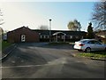
Burley Willows Day Centre
Adjacent to the similarly named care home Image
Image: © Stephen Craven
Taken: 20 Apr 2016
0.04 miles
5
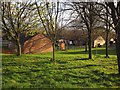
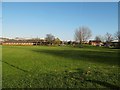
Housing at Burley Willows
A view from Burley Road. A group of closes all named Willow something clusters behind these trees and this grass on the south side of the Burley Road.
Image: © Derek Harper
Taken: 4 Apr 2012
0.04 miles
6

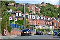
Burley Road from Woodsley Road junction, Leeds
Looking west along Burley Road from the pavement opposite the junction with Woodsley Road.
Image: © Rich Tea
Taken: 12 Jan 2006
0.04 miles
7
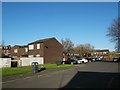
Willow Avenue, Leeds
Low rise housing off Burley Road. The denser pre-war housing on this site did include streets called Willow Road, Place, Street and Grove, so the historical association has been retained.
Image: © Stephen Craven
Taken: 20 Apr 2016
0.05 miles
8
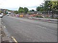
Road widening, Burley Road
Burley Road is being widened between Park Lane and Cardigan Road. This is the western end looking at the junction of Willow Approach. According to the council's signs it is now an "Integrated Transport Corridor" - I suppose that means it will include a bus lane.
Image: © Rich Tea
Taken: 18 May 2007
0.05 miles
10
Open space north of Kirkstall Road(1)
The area was cleared of densely packed terraced housing after WW2, but this bit has not been rebuilt.
Image: © Stephen Craven
Taken: 20 Apr 2016
0.06 miles