IMAGES TAKEN NEAR TO
Mount Preston Street, LEEDS, LS2 9NQ
Introduction
This page details the photographs taken nearby to Mount Preston Street, LS2 9NQ by members of the Geograph project.
The Geograph project started in 2005 with the aim of publishing, organising and preserving representative images for every square kilometre of Great Britain, Ireland and the Isle of Man.

There are currently over 7.5m images from over14,400 individuals and you can help contribute to the project by visiting https://www.geograph.org.uk
Image Map
Images are licensed for reuse under creativecommons.org/licenses/by-sa/2.0
Notes
- Clicking on the map will re-center to the selected point.
- The higher the marker number, the further away the image location is from the centre of the postcode.
Image Listing (285 Images Found)
Images are licensed for reuse under creativecommons.org/licenses/by-sa/2.0
Image
Details
Distance
1
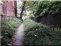
Path at the end of Springfield Mount
The path leads to Mount Preston Street.
Image: © Stephen Craven
Taken: 13 Oct 2021
0.01 miles
3
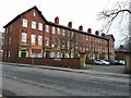
Woodsley Terrace, Clarendon Road, Leeds
A grade II listed terrace of eight town houses dating from 1856 (list entry 1255607).
Image: © Stephen Craven
Taken: 5 Mar 2021
0.02 miles
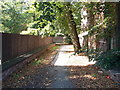
4
Mount Preston Street, Leeds
Looking eastwards from Clarendon Road. The street is part of a signed cycle route to the city centre.
Image: © Stephen Craven
Taken: 5 Mar 2021
0.03 miles
5
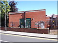
Meter Rooms - Mount Preston Street
Image: © Betty Longbottom
Taken: 10 Aug 2012
0.03 miles
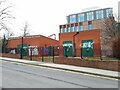
6
Meter Rooms - Mount Preston Street
Image: © Betty Longbottom
Taken: 10 Aug 2012
0.03 miles
7
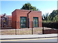
Substation, Mount Preston Street, Leeds
This is a principal 33kV/11kV substation, presumably providing power to the university campus on the edge of which it is situated.
Image: © Stephen Craven
Taken: 5 Mar 2021
0.03 miles
8
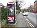
Phone box, Clarendon Road, Leeds
This box does still contain a phone, but has been heavily covered with graffiti.
Image: © Stephen Craven
Taken: 5 Mar 2021
0.04 miles
9
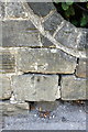
Benchmark on wall on east side of Clarendon Road
Ordnance Survey cut mark benchmark described on the Bench Mark Database at http://www.bench-marks.org.uk/bm50527
Image: © Roger Templeman
Taken: 26 Jul 2013
0.04 miles
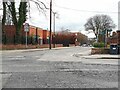
10
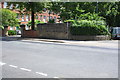
Junction of Kelso Road and Clarendon Road
There is an OS benchmark Image on the wall right of the parking restriction sign where the wall curves between different height sections
Image: © Roger Templeman
Taken: 26 Jul 2013
0.04 miles