IMAGES TAKEN NEAR TO
Back Raglan Road, LEEDS, LS2 9EA
Introduction
This page details the photographs taken nearby to Back Raglan Road, LS2 9EA by members of the Geograph project.
The Geograph project started in 2005 with the aim of publishing, organising and preserving representative images for every square kilometre of Great Britain, Ireland and the Isle of Man.

There are currently over 7.5m images from over14,400 individuals and you can help contribute to the project by visiting https://www.geograph.org.uk
Image Map (Loading...)


Getting Data...Please wait
Leaflet Map data © OpenStreetMap
Images are licensed for reuse under creativecommons.org/licenses/by-sa/2.0
Notes
- Clicking on the map will re-center to the selected point.
- The higher the marker number, the further away the image location is from the centre of the postcode.
Image Listing (285 Images Found)
Images are licensed for reuse under creativecommons.org/licenses/by-sa/2.0
Image
Details
Distance
1
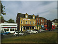
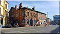
Shops on Raglan Road (2)
Including the Balti King restaurant.
Image: © Stephen Craven
Taken: 12 May 2017
0.00 miles
2
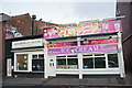
Bike Shops of Leeds (former)
Understood to have been Dave's Bike Shop in the early 1980's.
Image: © Rick Carn
Taken: 15 Dec 2011
0.02 miles
3
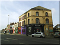
Shops on Raglan Road (1)
Nearest Woodhouse Lane, with Fortune Fisheries nearest the camera.
Image: © Stephen Craven
Taken: 12 May 2017
0.02 miles
5
Pack Horse Pub, Woodhouse Lane, Leeds
Image: © Mark Stevenson
Taken: 14 Mar 2016
0.03 miles
6
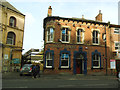
The Packhorse, Woodhouse Lane
A grade 2 listed pub (list entry 1255655), dating from 1870 and retaining its Victorian features. It is very popular with students, forming part of the 'Otley Run' pub crawl, and when I went in it was too crowded to take any photos of the historic interior.
Image: © Stephen Craven
Taken: 12 May 2017
0.03 miles
7
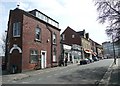
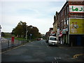
Raglan Road, Leeds
The first part of the Leeds link to the Dales Way is not the most attractive, but there is a female head, looking rather like one on a ship's figurehead, to wish you luck.
Image: © Humphrey Bolton
Taken: 19 Mar 2010
0.03 miles
8
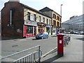
Raglan Road, Leeds
The southern end of the street is closed to traffic, and is the starting point of the Leeds link to the Dales Way, perhaps chosen because it is opposite the top end of the university. If you want to park a car you have to hunt for a space around Woodhouse Moor.
Image: © Humphrey Bolton
Taken: 19 Mar 2010
0.03 miles
9
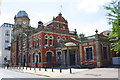
'The Library', #229 Woodhouse Lane
Once a place to read books, now a place to sup. There is an OS benchmark Image on the front on the near corner at the right hand side of the image
Image: © Roger Templeman
Taken: 26 Jul 2013
0.04 miles
10
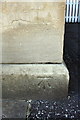
Benchmark on 'The Library' pub
Ordnance Survey cut mark benchmark described on the Bench Mark Database at http://www.bench-marks.org.uk/bm48168
Image: © Roger Templeman
Taken: 26 Jul 2013
0.04 miles