IMAGES TAKEN NEAR TO
Blenheim Crescent, LEEDS, LS2 9AY
Introduction
This page details the photographs taken nearby to Blenheim Crescent, LS2 9AY by members of the Geograph project.
The Geograph project started in 2005 with the aim of publishing, organising and preserving representative images for every square kilometre of Great Britain, Ireland and the Isle of Man.

There are currently over 7.5m images from over14,400 individuals and you can help contribute to the project by visiting https://www.geograph.org.uk
Image Map
Images are licensed for reuse under creativecommons.org/licenses/by-sa/2.0
Notes
- Clicking on the map will re-center to the selected point.
- The higher the marker number, the further away the image location is from the centre of the postcode.
Image Listing (278 Images Found)
Images are licensed for reuse under creativecommons.org/licenses/by-sa/2.0
Image
Details
Distance
5
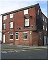
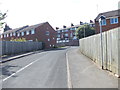
Former Manor Dairies - Devon Street, Leicester Place
Image: © Betty Longbottom
Taken: 8 Sep 2008
0.06 miles
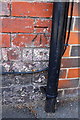
7
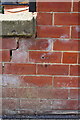
Benchmark on side wall of #2 Archery Place
Ordnance Survey cut mark benchmark described on the Bench Mark Database at http://www.Bench-marks.org.uk/bm50489
Image: © Roger Templeman
Taken: 26 Jul 2013
0.07 miles
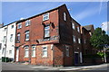
8
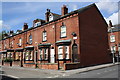
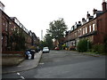
Houses at Archery Place / Archery Road junction
There is an OS benchmark Image on the side of the end house at the junction with its side 'front garden' wall
Image: © Roger Templeman
Taken: 26 Jul 2013
0.07 miles
9
Benchmark on #40 Devon Road
Ordnance Survey cut mark benchmark described on the Bench Mark Database at http://www.bench-marks.org.uk/bm50490
Image: © Roger Templeman
Taken: 26 Jul 2013
0.07 miles
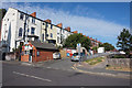
10
Junction of Devon Road and Leicester Place
There is an OS benchmark Image on the Leicester Place face (in the shade) of the corner building which evidently was a shop selling Milk, Cream and Curds.
Image: © Roger Templeman
Taken: 26 Jul 2013
0.07 miles