IMAGES TAKEN NEAR TO
Holme Grove, ILKLEY, LS29 7QD
Introduction
This page details the photographs taken nearby to Holme Grove, LS29 7QD by members of the Geograph project.
The Geograph project started in 2005 with the aim of publishing, organising and preserving representative images for every square kilometre of Great Britain, Ireland and the Isle of Man.

There are currently over 7.5m images from over14,400 individuals and you can help contribute to the project by visiting https://www.geograph.org.uk
Image Map (Loading...)


Getting Data...Please wait
Leaflet Map data © OpenStreetMap
Images are licensed for reuse under creativecommons.org/licenses/by-sa/2.0
Notes
- Clicking on the map will re-center to the selected point.
- The higher the marker number, the further away the image location is from the centre of the postcode.
Image Listing (39 Images Found)
Images are licensed for reuse under creativecommons.org/licenses/by-sa/2.0
Image
Details
Distance
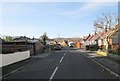
5
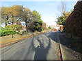
Menston Old Lane - viewed from Endor Crescent
Image: © Betty Longbottom
Taken: 25 Nov 2013
0.09 miles
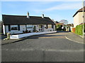
6
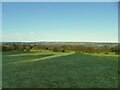
View north-east from outside Menston
Image: © Stephen Craven
Taken: 30 Dec 2020
0.10 miles
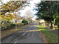
8

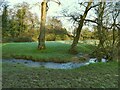
Muddy diverted footpath
Even recent maps show the public footpath crossing a field diagonally here, but it has been fenced off and official diversion notices send walkers through this very muddy patch of woodland.
Image: © Stephen Craven
Taken: 30 Dec 2020
0.10 miles
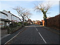
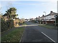
9

Carr Beck emerges from a railway culvert
Image: © Stephen Craven
Taken: 30 Dec 2020
0.10 miles