IMAGES TAKEN NEAR TO
Station Road, ILKLEY, LS29 7ND
Introduction
This page details the photographs taken nearby to Station Road, LS29 7ND by members of the Geograph project.
The Geograph project started in 2005 with the aim of publishing, organising and preserving representative images for every square kilometre of Great Britain, Ireland and the Isle of Man.

There are currently over 7.5m images from over14,400 individuals and you can help contribute to the project by visiting https://www.geograph.org.uk
Image Map (Loading...)


Getting Data...Please wait
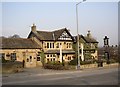
Leaflet Map data © OpenStreetMap
Images are licensed for reuse under creativecommons.org/licenses/by-sa/2.0
Notes
- Clicking on the map will re-center to the selected point.
- The higher the marker number, the further away the image location is from the centre of the postcode.
Image Listing (187 Images Found)
Images are licensed for reuse under creativecommons.org/licenses/by-sa/2.0
Image
Details
Distance
1
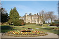
The Grange, Burley in Wharfedale
Once used as an education centre, now empty awaiting decision as to its future
Image: © John Sparshatt
Taken: 31 Mar 2008
0.01 miles
2
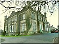
The Grange, Burley-in-Wharfedale
Burley Grange was built in 1840. Its history of use and ownership is given in detail on a local history website https://burleycommunitylibrary.weebly.com/burley-grange.html, but in short it was a residence until 1904, when it became offices for successive local authorities, most recently Bradford Met, until 1986. It then became a college building until 2006 and is currently occupied by a private clinic. Listed grade II (list entry 1314249). See also Image
Image: © Stephen Craven
Taken: 30 Dec 2020
0.01 miles
4
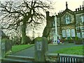
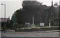
Burley-in-Wharfedale war memorial
The memorial outside The Grange is approached between stone pillars bearing the figures of soldiers. See also Image
Image: © Stephen Craven
Taken: 30 Dec 2020
0.02 miles
5
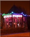
Round House, Burley-in-Wharfedale
Former estate greenhouse now used by the community for meetings and coffee mornings. Decorated for Christmas
Image: © John Sparshatt
Taken: 2 Dec 2012
0.02 miles
6
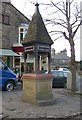
Drinking Fountain, Main Street / Station Road, Burley in Wharfedale
“Given in 1885...to the village” Unfortunately I forgot to look at the other side, but it seems that the fountain was two years early for Q. Victoria's Golden Jubilee.
Image: © Humphrey Bolton
Taken: 20 Feb 2008
0.02 miles
7
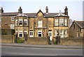
Brumfitt Villas, Main Street, Burley in Wharfedale
A large house and a smaller one, dated 1879. The smaller one on the right is faced, for some reason, with a different type of stone.
Image: © Humphrey Bolton
Taken: 20 Feb 2008
0.02 miles
8
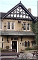
Detail of the Red Lion Main Street Burley in Wharfedale
The datestone records the rebuilding of the pub in 1893, with initials difficult to decipher – W, W & C or W, C & W.
Image: © Humphrey Bolton
Taken: 20 Feb 2008
0.02 miles
9
The Red Lion, Main Street, Burley in Wharfedale
Rebuilt in 1893, in the picturesque mock half-timbered style.
Image: © Humphrey Bolton
Taken: 20 Feb 2008
0.02 miles
10
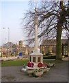
War Memorial, Main Street, Burley in Wharfedale
In front of The Grange (the former council offices). Queen's Hall is in the background on the left.
Image: © Humphrey Bolton
Taken: 20 Feb 2008
0.02 miles