IMAGES TAKEN NEAR TO
Summer Court, LS29 7NA
Introduction
This page details the photographs taken nearby to Summer Court, LS29 7NA by members of the Geograph project.
The Geograph project started in 2005 with the aim of publishing, organising and preserving representative images for every square kilometre of Great Britain, Ireland and the Isle of Man.

There are currently over 7.5m images from over14,400 individuals and you can help contribute to the project by visiting https://www.geograph.org.uk
Image Map
Images are licensed for reuse under creativecommons.org/licenses/by-sa/2.0
Notes
- Clicking on the map will re-center to the selected point.
- The higher the marker number, the further away the image location is from the centre of the postcode.
Image Listing (44 Images Found)
Images are licensed for reuse under creativecommons.org/licenses/by-sa/2.0
Image
Details
Distance
1
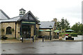
The Generous Pioneer public house and carvery
Image: © Mark Anderson
Taken: 4 Oct 2020
0.02 miles
2
Burley-in-Wharfedale, Yorkshire
Generous Pioneer Public House
Image: © John Sparshatt
Taken: 25 Dec 2012
0.03 miles
4
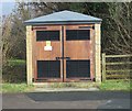
Electricity Substation No 48322 - Ilkley Road
Image: © Betty Longbottom
Taken: 9 Dec 2013
0.03 miles
7
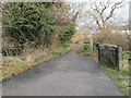
Burley-in-Wharfedale, Yorkshire
Bridleway underpass under the A65 Burley bypass road.
Image: © John Sparshatt
Taken: 25 Dec 2012
0.07 miles
9
Ghyll Royd School Burley-in-Wharfedale
Playing Fields
Image: © John Sparshatt
Taken: 25 Dec 2012
0.11 miles