IMAGES TAKEN NEAR TO
Sun Lane, ILKLEY, LS29 7LJ
Introduction
This page details the photographs taken nearby to Sun Lane, LS29 7LJ by members of the Geograph project.
The Geograph project started in 2005 with the aim of publishing, organising and preserving representative images for every square kilometre of Great Britain, Ireland and the Isle of Man.

There are currently over 7.5m images from over14,400 individuals and you can help contribute to the project by visiting https://www.geograph.org.uk
Image Map
Images are licensed for reuse under creativecommons.org/licenses/by-sa/2.0
Notes
- Clicking on the map will re-center to the selected point.
- The higher the marker number, the further away the image location is from the centre of the postcode.
Image Listing (56 Images Found)
Images are licensed for reuse under creativecommons.org/licenses/by-sa/2.0
Image
Details
Distance
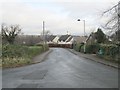
5
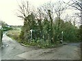
Path junction on Sun Lane
Both branches bear the name Sun Lane; the branch to the right is a public footpath and to the right is a bridleway.
Image: © Stephen Craven
Taken: 30 Dec 2020
0.03 miles
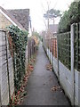
10

Footpath off Hall Drive
As with many such urban footpaths, this one seems to follow more-or-less the route of an older path predating the housing development.
Image: © Stephen Craven
Taken: 30 Dec 2020
0.04 miles