IMAGES TAKEN NEAR TO
West View Road, ILKLEY, LS29 7LE
Introduction
This page details the photographs taken nearby to West View Road, LS29 7LE by members of the Geograph project.
The Geograph project started in 2005 with the aim of publishing, organising and preserving representative images for every square kilometre of Great Britain, Ireland and the Isle of Man.

There are currently over 7.5m images from over14,400 individuals and you can help contribute to the project by visiting https://www.geograph.org.uk
Image Map (159 Images)


Getting Data...Please wait
Leaflet Map data © OpenStreetMap
Images are licensed for reuse under creativecommons.org/licenses/by-sa/2.0
Notes
- Clicking on the map will re-center to the selected point.
- The higher the marker number, the further away the image location is from the centre of the postcode.
Image Listing (159 Images Found)
Images are licensed for reuse under creativecommons.org/licenses/by-sa/2.0
Image
Details
Distance
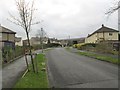
2
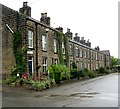
Booth Street - off Main Street, Burley
Image: © Betty Longbottom
Taken: 5 Aug 2008
0.03 miles
3
Aireville Terrace - looking towards Station Road
Image: © Betty Longbottom
Taken: 5 Mar 2014
0.05 miles
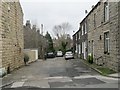
4
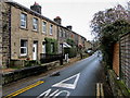
Sun Lane, Burley in Wharfedale
Terraced houses on Sun Lane, just before it joins Main Street.
Image: © Chris Heaton
Taken: 4 Dec 2012
0.05 miles
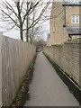
5
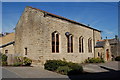
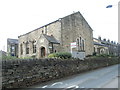
The Old Chapel, Sun Lane, Burley-in-Wharfedale
Now converted to living accommodation.
Image: © John Sparshatt
Taken: 31 Mar 2008
0.06 miles
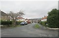
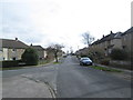
7
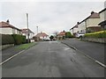
West View Avenue - looking towards West View Road
Image: © Betty Longbottom
Taken: 9 Dec 2013
0.06 miles