IMAGES TAKEN NEAR TO
Lapwing Avenue, LS29 6SG
Introduction
This page details the photographs taken nearby to Lapwing Avenue, LS29 6SG by members of the Geograph project.
The Geograph project started in 2005 with the aim of publishing, organising and preserving representative images for every square kilometre of Great Britain, Ireland and the Isle of Man.

There are currently over 7.5m images from over14,400 individuals and you can help contribute to the project by visiting https://www.geograph.org.uk
Image Map
Images are licensed for reuse under creativecommons.org/licenses/by-sa/2.0
Notes
- Clicking on the map will re-center to the selected point.
- The higher the marker number, the further away the image location is from the centre of the postcode.
Image Listing (62 Images Found)
Images are licensed for reuse under creativecommons.org/licenses/by-sa/2.0
Image
Details
Distance
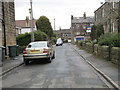
7
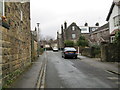
Dick's Garth Road - looking towards Main Street
Image: © Betty Longbottom
Taken: 17 Apr 2013
0.08 miles
8
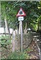
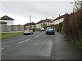
Road Sign - Derry Hill
This does not seem very appropriate on a very hot Saturday in August!
Image: © Betty Longbottom
Taken: 3 Aug 2013
0.09 miles
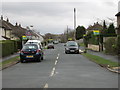
10
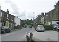
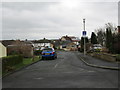
Derry Hill - Main Street, Menston
Image: © Betty Longbottom
Taken: 15 Aug 2008
0.11 miles