IMAGES TAKEN NEAR TO
High Royds Drive, ILKLEY, LS29 6QP
Introduction
This page details the photographs taken nearby to High Royds Drive, LS29 6QP by members of the Geograph project.
The Geograph project started in 2005 with the aim of publishing, organising and preserving representative images for every square kilometre of Great Britain, Ireland and the Isle of Man.

There are currently over 7.5m images from over14,400 individuals and you can help contribute to the project by visiting https://www.geograph.org.uk
Image Map
Images are licensed for reuse under creativecommons.org/licenses/by-sa/2.0
Notes
- Clicking on the map will re-center to the selected point.
- The higher the marker number, the further away the image location is from the centre of the postcode.
Image Listing (79 Images Found)
Images are licensed for reuse under creativecommons.org/licenses/by-sa/2.0
Image
Details
Distance
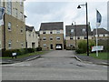
1
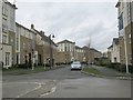
Kingsdale Drive - High Royds Drive
Image: © Betty Longbottom
Taken: 17 Apr 2013
0.01 miles
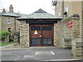
2
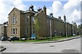
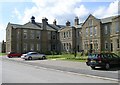
High Royds Mental Hospital - Menston
This block has now been converted for residential use.
Image: © Betty Longbottom
Taken: 15 Aug 2008
0.02 miles
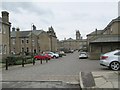
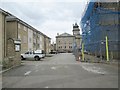
6
Electricity Substation No 48155 - Clifford Drive
Image: © Betty Longbottom
Taken: 17 Apr 2013
0.06 miles
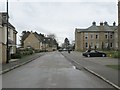
7
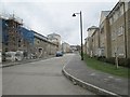
High Royds Drive - viewed from Clifford Drive
Image: © Betty Longbottom
Taken: 17 Apr 2013
0.06 miles
9
High Royds Mental Hospital - Menston
This block has now been converted for residential use.
Image: © Betty Longbottom
Taken: 15 Aug 2008
0.08 miles
10
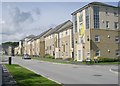
New Housing on site of High Royds Mental Hospital - Menston
Image: © Betty Longbottom
Taken: 15 Aug 2008
0.08 miles