IMAGES TAKEN NEAR TO
Main Street, ILKLEY, LS29 6NB
Introduction
This page details the photographs taken nearby to Main Street, LS29 6NB by members of the Geograph project.
The Geograph project started in 2005 with the aim of publishing, organising and preserving representative images for every square kilometre of Great Britain, Ireland and the Isle of Man.

There are currently over 7.5m images from over14,400 individuals and you can help contribute to the project by visiting https://www.geograph.org.uk
Image Map
Images are licensed for reuse under creativecommons.org/licenses/by-sa/2.0
Notes
- Clicking on the map will re-center to the selected point.
- The higher the marker number, the further away the image location is from the centre of the postcode.
Image Listing (88 Images Found)
Images are licensed for reuse under creativecommons.org/licenses/by-sa/2.0
Image
Details
Distance
1
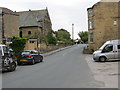
The north-western end of Main Street in Menston
Looking south-eastward.
Image: © Peter Wood
Taken: 11 Aug 2017
0.00 miles
3
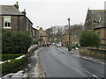
Main Street, Menston
Downtown Menston, on a cold and dull winter morning.
Image: © Chris Heaton
Taken: 7 Feb 2012
0.02 miles
4
Malt Shovel - Main Street, Menston
Image: © Betty Longbottom
Taken: 15 Aug 2008
0.02 miles
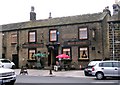
7
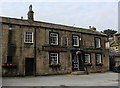
The Malt Shovel, Menston
Located on Main Street - and passed by on the Ebor Way and Dales Way Leeds Link long distance footpaths
Image: © Chris Heaton
Taken: 11 Sep 2020
0.03 miles
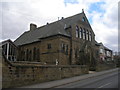
9
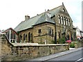
Wesleyan Chapel - Main Street, Menston
Image: © Betty Longbottom
Taken: 15 Aug 2008
0.03 miles
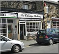
10
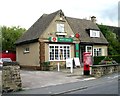
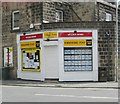
Menston Post Office - Main Street
Image: © Betty Longbottom
Taken: 15 Aug 2008
0.04 miles