IMAGES TAKEN NEAR TO
Jackson Walk, ILKLEY, LS29 6FD
Introduction
This page details the photographs taken nearby to Jackson Walk, LS29 6FD by members of the Geograph project.
The Geograph project started in 2005 with the aim of publishing, organising and preserving representative images for every square kilometre of Great Britain, Ireland and the Isle of Man.

There are currently over 7.5m images from over14,400 individuals and you can help contribute to the project by visiting https://www.geograph.org.uk
Image Map (Loading...)


Getting Data...Please wait
Leaflet Map data © OpenStreetMap
Images are licensed for reuse under creativecommons.org/licenses/by-sa/2.0
Notes
- Clicking on the map will re-center to the selected point.
- The higher the marker number, the further away the image location is from the centre of the postcode.
Image Listing (70 Images Found)
Images are licensed for reuse under creativecommons.org/licenses/by-sa/2.0
Image
Details
Distance
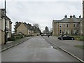
2
Electricity Substation No 48155 - Clifford Drive
Image: © Betty Longbottom
Taken: 17 Apr 2013
0.02 miles
3
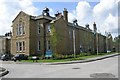
High Royds Mental Hospital - Menston
This block has now been converted for residential use.
Image: © Betty Longbottom
Taken: 15 Aug 2008
0.02 miles
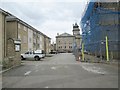
4
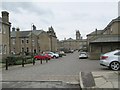
Kingsdale Drive - High Royds Drive
Image: © Betty Longbottom
Taken: 17 Apr 2013
0.03 miles
6
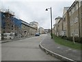
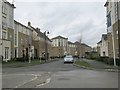
High Royds Drive - viewed from Clifford Drive
Image: © Betty Longbottom
Taken: 17 Apr 2013
0.03 miles
7
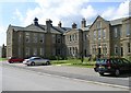
High Royds Mental Hospital - Menston
This block has now been converted for residential use.
Image: © Betty Longbottom
Taken: 15 Aug 2008
0.05 miles
8
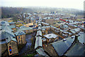
High Royds
Rooftops and towers as far as the eye can see, The towers are from no fairy tale town though. This was a self contained town for the Insane.
This is High Royds, the former West Riding and Pauper Lunatic Asylum in Menston, Burley in Wharfedale. Yorkshire.
This view is from the clock tower of the main administration building.
High Royds was one of the last remaining psychiatric hospitals of its kind still functioning when it closed in February 2003. Opening on 8 October 1888 it was then known as West Riding Pauper Lunatic Asylum. It was the third establishment of its kind in the former West Riding of Yorkshire.
The hospital site included at one stage a library, surgery, dispensary, ballroom, butchers, dairies, bakers and even its own railway. By the 1930’s a sweetshop, cobbler, upholsterer and a tailor were all added turning the hospital into a small self-contained village.
Image: © philld
Taken: 4 Nov 2007
0.05 miles
10
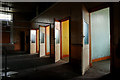
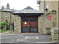
High Royds solitary confinement
This is away from the marble floors, Glazed tiles and grandiose of the Main administration block of High Royds. This is the side of High Royds the visitors wouldn't see.
Here people considered unfit to live in society, would be kept under lock and key, and forgotten about as a problem nicely brushed under the carpet.
Not all people interned in Asylums had mental health problems, single mothers whose only crime was to have a child outside of wedlock were considered a disgrace to society in Victorian days, and were locked away for there crimes against morality.
Experimental lobotomies were carried out to try find a cure for insanity here.
High Royds was one of the last remaining psychiatric hospitals of its kind still functioning when it closed in February 2003. Opening on 8 October 1888 it was then known as West Riding Pauper Lunatic Asylum. It was the third establishment of its kind in the former West Riding of Yorkshire,
The hospital site included at one stage a library, surgery, dispensary, ballroom, butchers, dairies, bakers and even its own railway. By the 1930s a sweetshop, cobbler, upholsterer and a tailor were all added turning the hospital into a small self-contained village.
Image: © philld
Taken: 8 Dec 2007
0.07 miles