IMAGES TAKEN NEAR TO
Skipton Road, ILKLEY, LS29 0JS
Introduction
This page details the photographs taken nearby to Skipton Road, LS29 0JS by members of the Geograph project.
The Geograph project started in 2005 with the aim of publishing, organising and preserving representative images for every square kilometre of Great Britain, Ireland and the Isle of Man.

There are currently over 7.5m images from over14,400 individuals and you can help contribute to the project by visiting https://www.geograph.org.uk
Image Map
Images are licensed for reuse under creativecommons.org/licenses/by-sa/2.0
Notes
- Clicking on the map will re-center to the selected point.
- The higher the marker number, the further away the image location is from the centre of the postcode.
Image Listing (14 Images Found)
Images are licensed for reuse under creativecommons.org/licenses/by-sa/2.0
Image
Details
Distance
1
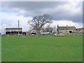
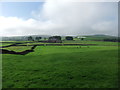
Highfield Farm
A working farm near Addingham.
Image: © John Illingworth
Taken: 30 Apr 2008
0.01 miles
2
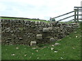
Stile, boundary, boundary marker and valve house
The stile carries the public footpath between Highfield Farm and Berwick East. The wall is the boundary between Bradford MDC, West Yorkshire [this / south side] and Craven, North Yorkshire [far / north side]. The BCWW boundary marker refers to Bradford Corporation Water Works, which opened the nearby Chelker reservoir in 1866. On the horizon is the valve house, which relates to the covered pipeline Image immediately to the right of this image.
Image: © Christine Johnstone
Taken: 28 May 2023
0.08 miles
3

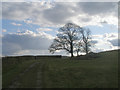
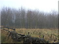
Cattle at Highfield Farm
Silhouetted in descending September sunlight
Image: © Neil Theasby
Taken: 15 Sep 2015
0.12 miles
4
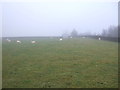
Sheep grazing near Highfield Farm
Off the A65.
Image: © JThomas
Taken: 17 Dec 2016
0.15 miles
6
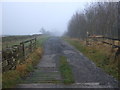
Track (footpath) to Highfield Farm
Off the A65.
Image: © JThomas
Taken: 17 Dec 2016
0.16 miles
8
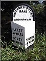
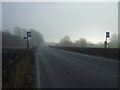
Old Milestone by the A65, west of Highfield House, Addingham parish
Metal plate attached to stone post by the A65, in parish of ADDINGHAM (BRADFORD District), 250m Northwest of entrance to Highfield House, in verge next to drystone wall, on North side of road. WR iron casting, erected by the County Council in the 19th century.
Inscription reads:-
: ILKLEY / 4¼ MILES / OTLEY / 10¾ MILES : : SKIPTON & OTLEY / ROAD / ADDINGHAM : : SKIPTON / 5 MILES :
Grade II listed.
List Entry Number: 1133446 https://historicengland.org.uk/listing/the-list/list-entry/1133446
Milestone Society National ID: YW_SKOT05.
Image: © C Minto
Taken: 15 Sep 2002
0.19 miles