IMAGES TAKEN NEAR TO
Langbar, ILKLEY, LS29 0EL
Introduction
This page details the photographs taken nearby to LS29 0EL by members of the Geograph project.
The Geograph project started in 2005 with the aim of publishing, organising and preserving representative images for every square kilometre of Great Britain, Ireland and the Isle of Man.

There are currently over 7.5m images from over14,400 individuals and you can help contribute to the project by visiting https://www.geograph.org.uk
Image Map (Loading...)


Getting Data...Please wait
Leaflet Map data © OpenStreetMap
Images are licensed for reuse under creativecommons.org/licenses/by-sa/2.0
Notes
- Clicking on the map will re-center to the selected point.
- The higher the marker number, the further away the image location is from the centre of the postcode.
Image Listing (11 Images Found)
Images are licensed for reuse under creativecommons.org/licenses/by-sa/2.0
Image
Details
Distance
2
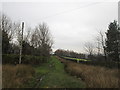
Footpath on Low Moor
A rather muddy soggy excuse for a footpath follows the stunted wall on Low Moor, heading towards Chapel House
Image: © Chris Heaton
Taken: 2 Nov 2011
0.08 miles
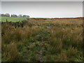
3
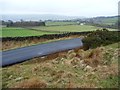
Low Moor, Langbar
Low Moor, close to where it gives way to improved land at about 250m above sea level in lower Wharfedale.
Image: © Gordon Hatton
Taken: 23 Nov 2010
0.11 miles
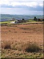
4
Chapel House Farm
Located on the NW edge of Low Moor, this is no longer a working farm. Note the former barns in the foreground which have been converted into residential accommodation.
Image: © Clare Smith
Taken: 3 Sep 2006
0.15 miles
5
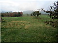
Rough Pasture behind Chapel House
The footpath follows the boundary fence towards Langbar
Image: © Chris Heaton
Taken: 2 Nov 2011
0.17 miles
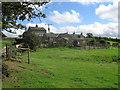
6
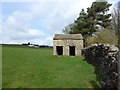
Bijou shippon near the head of Dean Beck
A small, but perfectly formed, example of typical field building architecture in Wharfedale
Image: © Lee Davidson
Taken: 15 Mar 2019
0.18 miles
7
Unmapped path on Middleton Low Moor
On the east side of Hardings Lane. A continuation of Nesfield Lane.
Image: © Christine Johnstone
Taken: 22 Feb 2015
0.23 miles
8
Fencing in a land of drystone walls
Field boundaries on the west side of Hardings Lane at Moor End, Langbar.
Image: © Christine Johnstone
Taken: 22 Feb 2015
0.24 miles
9
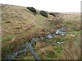
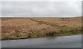
Moorland stream coming from Delves Tarn
About to pass under Hardings Lane.
Image: © Christine Johnstone
Taken: 22 Feb 2015
0.24 miles
10
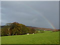
Rainbow in Langbar
A day of squally showers and sunny intervals in farmland north of Addingham.
Image: © Peter Barr
Taken: 11 Nov 2010
0.24 miles