IMAGES TAKEN NEAR TO
Lumby Close, PUDSEY, LS28 9JS
Introduction
This page details the photographs taken nearby to Lumby Close, LS28 9JS by members of the Geograph project.
The Geograph project started in 2005 with the aim of publishing, organising and preserving representative images for every square kilometre of Great Britain, Ireland and the Isle of Man.

There are currently over 7.5m images from over14,400 individuals and you can help contribute to the project by visiting https://www.geograph.org.uk
Image Map (Loading...)


Getting Data...Please wait
Leaflet Map data © OpenStreetMap
Images are licensed for reuse under creativecommons.org/licenses/by-sa/2.0
Notes
- Clicking on the map will re-center to the selected point.
- The higher the marker number, the further away the image location is from the centre of the postcode.
Image Listing (128 Images Found)
Images are licensed for reuse under creativecommons.org/licenses/by-sa/2.0
Image
Details
Distance
4
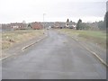
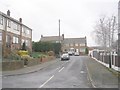
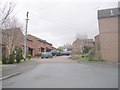
Walmer Grove - looking towards Kent Road
Image: © Betty Longbottom
Taken: 22 Jan 2011
0.06 miles
7
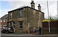
#13 Lumby Lane
There is an OS benchmark Image on the near corner of the house at pavement level left of a stone gatepost
Image: © Roger Templeman
Taken: 15 Apr 2017
0.08 miles
9
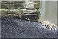
Benchmark at #13 Lumby Lane
Ordnance Survey cut mark benchmark described on the Bench Mark Database at https://www.bench-marks.org.uk/bm83883
Image: © Roger Templeman
Taken: 15 Apr 2017
0.09 miles