IMAGES TAKEN NEAR TO
Kent Avenue, PUDSEY, LS28 9ED
Introduction
This page details the photographs taken nearby to Kent Avenue, LS28 9ED by members of the Geograph project.
The Geograph project started in 2005 with the aim of publishing, organising and preserving representative images for every square kilometre of Great Britain, Ireland and the Isle of Man.

There are currently over 7.5m images from over14,400 individuals and you can help contribute to the project by visiting https://www.geograph.org.uk
Image Map
Images are licensed for reuse under creativecommons.org/licenses/by-sa/2.0
Notes
- Clicking on the map will re-center to the selected point.
- The higher the marker number, the further away the image location is from the centre of the postcode.
Image Listing (99 Images Found)
Images are licensed for reuse under creativecommons.org/licenses/by-sa/2.0
Image
Details
Distance
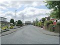
2
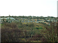
View West from Post Hill
The housing in the middle distance is around Kent Avenue Image Pudsey parish church top left.
Image: © Stephen Craven
Taken: 6 Jan 2018
0.03 miles

7
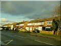
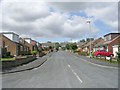
Low-rise housing on Kent Road, Pudsey
The nearest row of houses is built where there used to be a track to Larkfield Farm behind.
Image: © Stephen Craven
Taken: 5 Dec 2020
0.07 miles
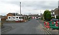
9
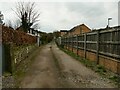
Track off Kent Road, Pudsey
A private road to a single dwelling, but not physically closed to walkers.
Image: © Stephen Craven
Taken: 23 Mar 2021
0.07 miles
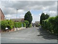
10
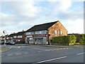
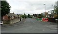
Kent Road Minimarket
At the end of Kent Crescent.
Image: © Stephen Craven
Taken: 5 Dec 2020
0.07 miles