IMAGES TAKEN NEAR TO
Gable End Terrace, PUDSEY, LS28 9BJ
Introduction
This page details the photographs taken nearby to Gable End Terrace, LS28 9BJ by members of the Geograph project.
The Geograph project started in 2005 with the aim of publishing, organising and preserving representative images for every square kilometre of Great Britain, Ireland and the Isle of Man.

There are currently over 7.5m images from over14,400 individuals and you can help contribute to the project by visiting https://www.geograph.org.uk
Image Map
Images are licensed for reuse under creativecommons.org/licenses/by-sa/2.0
Notes
- Clicking on the map will re-center to the selected point.
- The higher the marker number, the further away the image location is from the centre of the postcode.
Image Listing (255 Images Found)
Images are licensed for reuse under creativecommons.org/licenses/by-sa/2.0
Image
Details
Distance
1
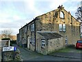
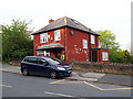
Gable End Terrace, Pudsey
Viewed from the Kent Road end. The reason for the name is obvious; note also the darkened stonework indicating the route of an internal chimney.
Image: © Stephen Craven
Taken: 5 Dec 2020
0.01 miles
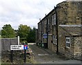
2
Lowtown Primary School, Pudsey
Viewed from the entrance on Kent Road.
Image: © Stephen Craven
Taken: 5 Dec 2020
0.03 miles
4
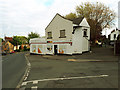
Go Local Extra, Kent Road, Pudsey
Described as a "community convenience store", but that doesn't mean it's run by a local co-operative. The brand is the retail arm of the wholesaler Parfetts Cash & Carry. The slightly odd positioning of the building relative to the road is explained by the fact that what is now Kent Road (left) was realigned at some time; it was formerly Crimbles Road and ran directly in front of the shop.
Image: © Stephen Craven
Taken: 1 May 2020
0.04 miles
5
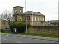
Office building with clock tower, Kent Road, Pudsey
This was part of the municipal gas works.
Image: © Humphrey Bolton
Taken: 4 Apr 2019
0.05 miles
6
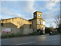
Clock tower, Kent Road, Pudsey
The clock tower may originally have belonged either to Albion Mill (which included the building to the left), or as a couple of other contributors have suggested, to the Crimbles Gas Works that occupied the site to the right from c.1845 until 1972. It is now part of the Pudsey Business Centre.
Image: © Stephen Craven
Taken: 5 Dec 2020
0.05 miles
8
House with defibrillator, Kent Road, Pudsey
Although now common in or on public buildings, it's still unusual to see one of these devices on a private house. Maybe a doctor lives here.
Image: © Stephen Craven
Taken: 1 May 2020
0.05 miles
9
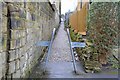
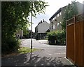
Footpath, Hillside Grove, Pudsey, Leeds
Image: © Mark Stevenson
Taken: 25 Jan 2016
0.06 miles
10
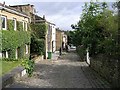
South View
This is a private road.
Image: © Betty Longbottom
Taken: 27 Sep 2007
0.06 miles