IMAGES TAKEN NEAR TO
Glenroyd Close, PUDSEY, LS28 8HN
Introduction
This page details the photographs taken nearby to Glenroyd Close, LS28 8HN by members of the Geograph project.
The Geograph project started in 2005 with the aim of publishing, organising and preserving representative images for every square kilometre of Great Britain, Ireland and the Isle of Man.

There are currently over 7.5m images from over14,400 individuals and you can help contribute to the project by visiting https://www.geograph.org.uk
Image Map
Images are licensed for reuse under creativecommons.org/licenses/by-sa/2.0
Notes
- Clicking on the map will re-center to the selected point.
- The higher the marker number, the further away the image location is from the centre of the postcode.
Image Listing (128 Images Found)
Images are licensed for reuse under creativecommons.org/licenses/by-sa/2.0
Image
Details
Distance
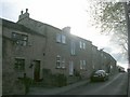
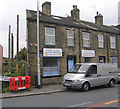
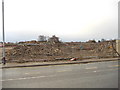
1
Former Engineering Works - Waterloo Road
Image: © Betty Longbottom
Taken: 10 May 2009
0.04 miles
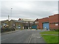
4
Glenroyd Mills & Smurfitt Kappa - Occupation Lane
Image: © Betty Longbottom
Taken: 6 Apr 2007
0.06 miles

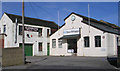
7
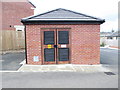
Electricity Substation No 52438 - Round Hill Road
Image: © Betty Longbottom
Taken: 5 Apr 2014
0.07 miles
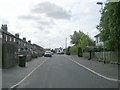
8
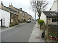
Round Hill Road - looking towards Uppermoor
Image: © Betty Longbottom
Taken: 5 Apr 2014
0.07 miles
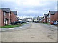
10
Bellway Building Development - Uppermoor
Image: © Betty Longbottom
Taken: 27 Dec 2011
0.08 miles