IMAGES TAKEN NEAR TO
Teasel Bank, PUDSEY, LS28 8DP
Introduction
This page details the photographs taken nearby to Teasel Bank, LS28 8DP by members of the Geograph project.
The Geograph project started in 2005 with the aim of publishing, organising and preserving representative images for every square kilometre of Great Britain, Ireland and the Isle of Man.

There are currently over 7.5m images from over14,400 individuals and you can help contribute to the project by visiting https://www.geograph.org.uk
Image Map
Images are licensed for reuse under creativecommons.org/licenses/by-sa/2.0
Notes
- Clicking on the map will re-center to the selected point.
- The higher the marker number, the further away the image location is from the centre of the postcode.
Image Listing (110 Images Found)
Images are licensed for reuse under creativecommons.org/licenses/by-sa/2.0
Image
Details
Distance
1
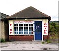
Waterloo Fisheries - Waterloo Road
Image: © Betty Longbottom
Taken: 12 Jul 2007
0.03 miles
2
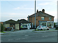
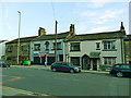
Shops and substation on Waterloo Road
Image: © Stephen Craven
Taken: 3 Aug 2020
0.03 miles
3
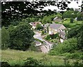
Gibraltar viewed from footpath around Round Hill
Image: © Betty Longbottom
Taken: 21 Jun 2007
0.04 miles
4
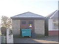
Electricity Substation No 876 - Waterloo Road
Image: © Betty Longbottom
Taken: 15 Nov 2010
0.04 miles
5
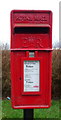
Elizabeth II postbox on Waterloo Road, Pudsey
Postbox No. LS28 796.
See Image] for context.
Image: © JThomas
Taken: 14 Feb 2020
0.05 miles
6
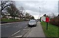
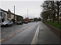
Waterloo Road, Pudsey
Showing position of Postbox No. LS28 796.
See Image] for postbox.
Image: © JThomas
Taken: 14 Feb 2020
0.05 miles
9
Convenience store and older houses, Waterloo Road
Formerly the Waterloo Off Licence Image
Image: © Stephen Craven
Taken: 3 Aug 2020
0.05 miles
10
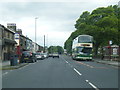
Waterloo Road in the Delph End district of Pudsey (LS28)
Looking north-westward.
Image: © Peter Wood
Taken: 16 Jan 2019
0.06 miles