IMAGES TAKEN NEAR TO
Priesthorpe Avenue, PUDSEY, LS28 7TF
Introduction
This page details the photographs taken nearby to Priesthorpe Avenue, LS28 7TF by members of the Geograph project.
The Geograph project started in 2005 with the aim of publishing, organising and preserving representative images for every square kilometre of Great Britain, Ireland and the Isle of Man.

There are currently over 7.5m images from over14,400 individuals and you can help contribute to the project by visiting https://www.geograph.org.uk
Image Map (Loading...)


Getting Data...Please wait
Leaflet Map data © OpenStreetMap
Images are licensed for reuse under creativecommons.org/licenses/by-sa/2.0
Notes
- Clicking on the map will re-center to the selected point.
- The higher the marker number, the further away the image location is from the centre of the postcode.
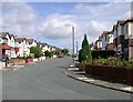
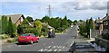
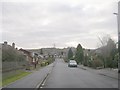
Image Listing (114 Images Found)
Images are licensed for reuse under creativecommons.org/licenses/by-sa/2.0
Image
Details
Distance
1
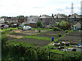
Allotments on Ring Road near Dawson's Corner
Image: © Betty Longbottom
Taken: 25 Apr 2007
0.04 miles
2
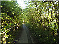
Path alongside the Leeds ring road near Dawson's Corner
The path is only separated from the road by the narrow belt of trees to the right.
Image: © Stephen Craven
Taken: 6 Jul 2020
0.04 miles
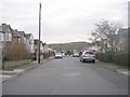
5
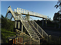
Footbridge over the Leeds ring road near Dawson's Corner
The bridge carries a pre-existing right of way.
Image: © Stephen Craven
Taken: 6 Jul 2020
0.06 miles
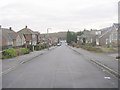
10
WDL Interior Architects - Dawson's Corner
Image: © Betty Longbottom
Taken: 26 Jan 2011
0.08 miles