IMAGES TAKEN NEAR TO
Mount Tabor Street, PUDSEY, LS28 7QA
Introduction
This page details the photographs taken nearby to Mount Tabor Street, LS28 7QA by members of the Geograph project.
The Geograph project started in 2005 with the aim of publishing, organising and preserving representative images for every square kilometre of Great Britain, Ireland and the Isle of Man.

There are currently over 7.5m images from over14,400 individuals and you can help contribute to the project by visiting https://www.geograph.org.uk
Image Map (Loading...)


Getting Data...Please wait
Leaflet Map data © OpenStreetMap
Images are licensed for reuse under creativecommons.org/licenses/by-sa/2.0
Notes
- Clicking on the map will re-center to the selected point.
- The higher the marker number, the further away the image location is from the centre of the postcode.
Image Listing (144 Images Found)
Images are licensed for reuse under creativecommons.org/licenses/by-sa/2.0
Image
Details
Distance
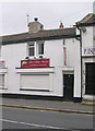
3
Pudsey Off Licence & Convenience Store - Waterloo Road
Image: © Betty Longbottom
Taken: 27 Sep 2009
0.02 miles
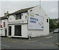
9
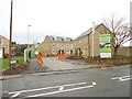
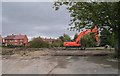
Mount Tabor Street
This was the site of the Mount Tabor Chapel.
Image: © Betty Longbottom
Taken: 12 Jul 2007
0.05 miles
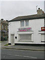
10
Site of the former Waterloo Infants' School - Waterloo Road
Image: © Betty Longbottom
Taken: 11 Oct 2007
0.05 miles