IMAGES TAKEN NEAR TO
Prospect Avenue, PUDSEY, LS28 7HN
Introduction
This page details the photographs taken nearby to Prospect Avenue, LS28 7HN by members of the Geograph project.
The Geograph project started in 2005 with the aim of publishing, organising and preserving representative images for every square kilometre of Great Britain, Ireland and the Isle of Man.

There are currently over 7.5m images from over14,400 individuals and you can help contribute to the project by visiting https://www.geograph.org.uk
Image Map
Images are licensed for reuse under creativecommons.org/licenses/by-sa/2.0
Notes
- Clicking on the map will re-center to the selected point.
- The higher the marker number, the further away the image location is from the centre of the postcode.
Image Listing (128 Images Found)
Images are licensed for reuse under creativecommons.org/licenses/by-sa/2.0
Image
Details
Distance
4
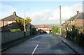
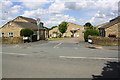
Queens Drive, Cemetery Road, Pudsey
Internet searches suggest this is a development for the over-55s only, built c.1996 and run by a private management company.
Image: © Stephen Craven
Taken: 26 Jan 2019
0.05 miles
5
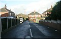
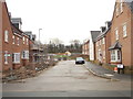
Junction of Queens Drive with Cemetery Road
Image: © Roger Templeman
Taken: 18 May 2017
0.06 miles
6
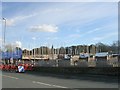
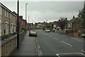
Royal Gardens Building Site - Cemetery Road
Houses etc are now being built on the site of Wilkinson Warburton's Caressa House.
Image: © Betty Longbottom
Taken: 6 Nov 2010
0.06 miles
9
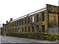
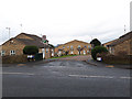
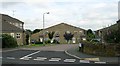
Grove Works - Cemetery Road
Mill now occupied by Wilkies
Image: © Betty Longbottom
Taken: 22 Mar 2007
0.06 miles
10
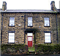
Mill House, Grove Works - Cemetery Road
Image: © Betty Longbottom
Taken: 22 Mar 2007
0.06 miles