IMAGES TAKEN NEAR TO
Bradford Road, PUDSEY, LS28 6QB
Introduction
This page details the photographs taken nearby to Bradford Road, LS28 6QB by members of the Geograph project.
The Geograph project started in 2005 with the aim of publishing, organising and preserving representative images for every square kilometre of Great Britain, Ireland and the Isle of Man.

There are currently over 7.5m images from over14,400 individuals and you can help contribute to the project by visiting https://www.geograph.org.uk
Image Map (Loading...)


Getting Data...Please wait
Leaflet Map data © OpenStreetMap
Images are licensed for reuse under creativecommons.org/licenses/by-sa/2.0
Notes
- Clicking on the map will re-center to the selected point.
- The higher the marker number, the further away the image location is from the centre of the postcode.
Image Listing (179 Images Found)
Images are licensed for reuse under creativecommons.org/licenses/by-sa/2.0
Image
Details
Distance
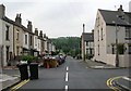
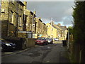
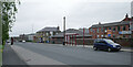
2
Bradford Road near Cote Lane
CS1, the Leeds-Bradford cycle superhighway running along Bradford Road.
Image: © DS Pugh
Taken: 26 May 2023
0.03 miles
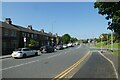
3
Pudsey Civic Hall
A public meeting hall in Farsley, not really in Pudsey proper.
Image: © David Spencer
Taken: 27 Aug 2005
0.04 miles
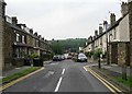
4
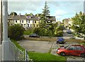
Woodlands Avenue, seen across a parking lot near New Pudsey station
Image: © Schlosser67
Taken: 2 Oct 2006
0.04 miles
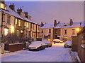
5
Alley between Bradford Road and Woodlands Grove
Image: © Schlosser67
Taken: 2 Oct 2006
0.04 miles
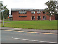
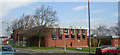
8
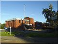
Pudsey police station
This is the only police station in west Leeds with public access.
Image: © Stephen Craven
Taken: 6 Jul 2020
0.05 miles
10
Pudsey Police Station - Dawson's Corner
Image: © Betty Longbottom
Taken: 15 Mar 2007
0.06 miles