IMAGES TAKEN NEAR TO
Granville Street, PUDSEY, LS28 6NF
Introduction
This page details the photographs taken nearby to Granville Street, LS28 6NF by members of the Geograph project.
The Geograph project started in 2005 with the aim of publishing, organising and preserving representative images for every square kilometre of Great Britain, Ireland and the Isle of Man.

There are currently over 7.5m images from over14,400 individuals and you can help contribute to the project by visiting https://www.geograph.org.uk
Image Map (Loading...)


Getting Data...Please wait
Leaflet Map data © OpenStreetMap
Images are licensed for reuse under creativecommons.org/licenses/by-sa/2.0
Notes
- Clicking on the map will re-center to the selected point.
- The higher the marker number, the further away the image location is from the centre of the postcode.
Image Listing (197 Images Found)
Images are licensed for reuse under creativecommons.org/licenses/by-sa/2.0
Image
Details
Distance

5
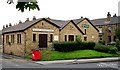
St John's Methodist Church - Stanningley
Image: © Betty Longbottom
Taken: 23 Jul 2007
0.02 miles
6
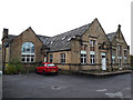
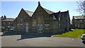
Victoria Court, Gladstone Terrace, Stanningley
The former Stanningley Infant School, which closed in 1981 and was later converted into apartments.
Image: © Stephen Craven
Taken: 3 Nov 2019
0.02 miles
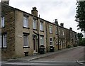
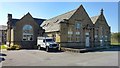
9
St John's Methodist church, Stanningley
Compare Image A modern building, but there has been a Methodist church on this site since 1885.
Image: © Stephen Craven
Taken: 6 Sep 2015
0.04 miles