IMAGES TAKEN NEAR TO
Conifer Gardens, LS28 6BT
Introduction
This page details the photographs taken nearby to Conifer Gardens, LS28 6BT by members of the Geograph project.
The Geograph project started in 2005 with the aim of publishing, organising and preserving representative images for every square kilometre of Great Britain, Ireland and the Isle of Man.

There are currently over 7.5m images from over14,400 individuals and you can help contribute to the project by visiting https://www.geograph.org.uk
Image Map
Images are licensed for reuse under creativecommons.org/licenses/by-sa/2.0
Notes
- Clicking on the map will re-center to the selected point.
- The higher the marker number, the further away the image location is from the centre of the postcode.
Image Listing (310 Images Found)
Images are licensed for reuse under creativecommons.org/licenses/by-sa/2.0
Image
Details
Distance
1
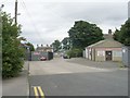
Parkfield Terrace - Richardshaw Road
Image: © Betty Longbottom
Taken: 23 Aug 2009
0.00 miles
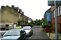
4
Richardshaw Road - Richardshaw Lane
Image: © Betty Longbottom
Taken: 23 Aug 2009
0.01 miles
5
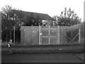
Gas Installation - Richardshaw Road
Image: © Betty Longbottom
Taken: 1 Feb 2011
0.02 miles
7
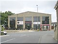
Grangefield Fisheries - Richardshaw Lane
Image: © Betty Longbottom
Taken: 4 Oct 2009
0.04 miles
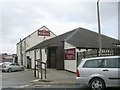
8
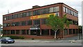
Kingswood House - Richardshaw Lane
This is an empty office block. At one time it housed the Inland Revenue office dealing with the taxation of Lloyds' underwriters.
Image: © Betty Longbottom
Taken: 26 Jul 2007
0.04 miles
9
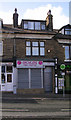
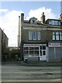
Growlers Pies & Pasties - Richardshaw Lane
Image: © Betty Longbottom
Taken: 4 Oct 2009
0.05 miles
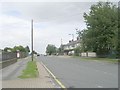
10
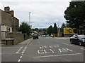
Richardshaw Lane (B6155) linking Pudsey with Stanningley
Looking north-westward towards Stanningley.
Image: © Peter Wood
Taken: 14 Jul 2017
0.05 miles