IMAGES TAKEN NEAR TO
Clara Drive, PUDSEY, LS28 5QP
Introduction
This page details the photographs taken nearby to Clara Drive, LS28 5QP by members of the Geograph project.
The Geograph project started in 2005 with the aim of publishing, organising and preserving representative images for every square kilometre of Great Britain, Ireland and the Isle of Man.

There are currently over 7.5m images from over14,400 individuals and you can help contribute to the project by visiting https://www.geograph.org.uk
Image Map (Loading...)


Getting Data...Please wait
Leaflet Map data © OpenStreetMap
Images are licensed for reuse under creativecommons.org/licenses/by-sa/2.0
Notes
- Clicking on the map will re-center to the selected point.
- The higher the marker number, the further away the image location is from the centre of the postcode.
Image Listing (69 Images Found)
Images are licensed for reuse under creativecommons.org/licenses/by-sa/2.0
Image
Details
Distance
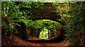
1

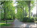
Clara Drive bridge over Calverley Cutting
See Image for a view from the other side.
Image: © Stephen Craven
Taken: 24 Mar 2021
0.07 miles
2
Clara Drive, Calverley - 25mph zone
Clara Drive is a private road but in practice open to the public. 25mph is an unusual speed limit. It is probably only advisory.
Image: © Stephen Craven
Taken: 13 May 2017
0.07 miles
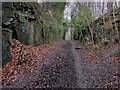
3
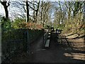
Ramp out of Calverley Cutting
I presume the path gives access to Clara Drive, the road that crosses the cutting by the bridge in the distance.
Image: © Stephen Craven
Taken: 24 Mar 2021
0.08 miles
4
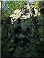
Clara Drive bridge over Calverley Cutting
A detail of the rock sides of the cutting. See Image for a view along the byway.
Image: © Stephen Craven
Taken: 24 Mar 2021
0.09 miles
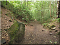
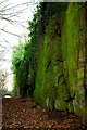
5
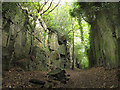
Calverley Cutting, looking uphill
The path through the cutting is quite steep (about 1:6 or 17%) Image; I had attempted to cycle up it but had to resort to walking, before riding again from this point where the gradient eases. Although it looks like a remote location there are in fact houses only a few metres either side of the top of the rock cutting.
Image: © Stephen Craven
Taken: 10 Sep 2016
0.10 miles
6
The Calverley Cutting
This road was cut through sandstone rock to provide a quicker and alternative way to the packhorse route through Calverley Woods in the 1850's. It did not prove to be that popular because of the steep incline from Apperley Bridge - the former route being easier and more scenic.
http://www.leodis.net/searchResults.aspx?LOCID=9999&DECADE=0&YEAR=&KEYWORDS=Calverley%20Cutting&KEYWORDS2=&KEYWORDS3=&ANDOR2=&ANDOR3=&RECSPAGE=5&VIEW=1&CURRPAGE=1
Image: © Chris Heaton
Taken: 19 Feb 2014
0.10 miles
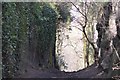
7
Calverley Cutting, looking downhill
The path through the cutting is quite steep (about 1:6 or 17%); I had attempted to cycle up it but had to resort to walking.
Image: © Stephen Craven
Taken: 10 Sep 2016
0.12 miles
10
Calverley Cutting, Calverley, Leeds
Image: © Mark Stevenson
Taken: 11 Dec 2013
0.12 miles