IMAGES TAKEN NEAR TO
Lawson Court, PUDSEY, LS28 5GS
Introduction
This page details the photographs taken nearby to Lawson Court, LS28 5GS by members of the Geograph project.
The Geograph project started in 2005 with the aim of publishing, organising and preserving representative images for every square kilometre of Great Britain, Ireland and the Isle of Man.

There are currently over 7.5m images from over14,400 individuals and you can help contribute to the project by visiting https://www.geograph.org.uk
Image Map (Loading...)


Getting Data...Please wait
Leaflet Map data © OpenStreetMap
Images are licensed for reuse under creativecommons.org/licenses/by-sa/2.0
Notes
- Clicking on the map will re-center to the selected point.
- The higher the marker number, the further away the image location is from the centre of the postcode.
Image Listing (218 Images Found)
Images are licensed for reuse under creativecommons.org/licenses/by-sa/2.0
Image
Details
Distance

2
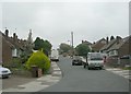
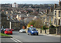
Springbank Road, Farsley
Looking downhill from the junction with Springbank Close.
Image: © Stephen Craven
Taken: 9 Jul 2021
0.04 miles
3

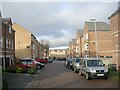
Broom Mills Road, off Coal Hill Lane
A modern low-rise development.
Image: © Stephen Craven
Taken: 17 Mar 2019
0.05 miles
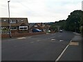
4
Building Site - between Springbank Road & Bagley Lane
Image: © Betty Longbottom
Taken: 31 Dec 2010
0.05 miles
5
Springbank Road - viewed from Springbank Close
Image: © Betty Longbottom
Taken: 4 May 2009
0.05 miles
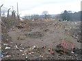
6

Beck Bottom Cottages - Coal Hill Lane
Image: © Betty Longbottom
Taken: 7 Jun 2007
0.05 miles
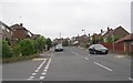
7
Broom Mills Road, Bagley
See Image for a closer view of some of the houses.
Image: © Stephen Craven
Taken: 19 Apr 2020
0.05 miles
8
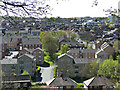
Coal Hill Lane
With the village of Farsley spread out below.
Image: © michael ely
Taken: 19 Mar 2011
0.06 miles
9
Lawson Court - off Broom Mills Road
Image: © Betty Longbottom
Taken: 31 Dec 2010
0.06 miles