IMAGES TAKEN NEAR TO
Regent Street, LEEDS, LS2 7QA
Introduction
This page details the photographs taken nearby to Regent Street, LS2 7QA by members of the Geograph project.
The Geograph project started in 2005 with the aim of publishing, organising and preserving representative images for every square kilometre of Great Britain, Ireland and the Isle of Man.

There are currently over 7.5m images from over14,400 individuals and you can help contribute to the project by visiting https://www.geograph.org.uk
Image Map
Images are licensed for reuse under creativecommons.org/licenses/by-sa/2.0
Notes
- Clicking on the map will re-center to the selected point.
- The higher the marker number, the further away the image location is from the centre of the postcode.
Image Listing (459 Images Found)
Images are licensed for reuse under creativecommons.org/licenses/by-sa/2.0
Image
Details
Distance
1
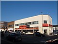
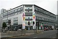
Floors 2 Go, Regent Street, Leeds
Floors 2 Go has moved from smaller premises next door since 2010 Image
Image: © Stephen Craven
Taken: 10 Sep 2015
0.00 miles
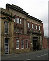
2
D I Silverton, Millwright Street, Leeds
A glimpse from the main A61 road of a quiet back street of older buildings. Silverton are jewellery wholesalers.
Image: © Stephen Craven
Taken: 10 Sep 2015
0.02 miles

4
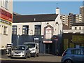
UCKG Help Centre, Regent Street, Leeds
One of several "help centres" around the UK run by the Universal Church of the Kingdom of God, this one opened on 31 January 2015. They appear to have taken over the building from Floors 2 Go Image who have moved to larger premises next door Image
Image: © Stephen Craven
Taken: 10 Sep 2015
0.03 miles
5

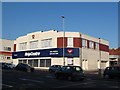
Shell Filling Station - Regent Street
Image: © Betty Longbottom
Taken: 21 Jan 2009
0.03 miles
6
Wings of Refuge Ministries, Regent Street, Leeds
A counselling and advice centre.
Image: © Stephen Craven
Taken: 10 Sep 2015
0.04 miles
7
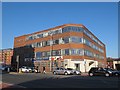
Pace Urban Apartments - Regent Street
Image: © Betty Longbottom
Taken: 19 Sep 2007
0.04 miles
8
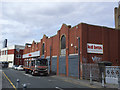
KD Brothers, Hope Road, Leeds
A car recovery service, one of many vehicle related businesses in the Mabgate area.
Image: © Stephen Craven
Taken: 25 Aug 2015
0.04 miles
10
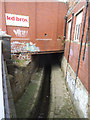
Lady Beck north of Hope Road, Leeds
Looking north-west from the bridge Image The stream bed has been engineered into a wider channel for storm flows, with a shallow invert channel for dry-weather flow. See also Image
The Lady Beck is a continuation of Sheepscar Beck, which flows from origins on Otley Chevin, through Bramhope, Adel, Meanwood, and was the site of much early industry in Leeds. The name was derived from a Medieval Chantry Chapel, at the junction of Lady Lane and Templar Lane. Its confluence with River Aire is east of the Parish Church of St Peter [now the Minster]. (source: Leodis website).
Image: © Stephen Craven
Taken: 25 Aug 2015
0.04 miles