IMAGES TAKEN NEAR TO
Old Road, LEEDS, LS27 7TH
Introduction
This page details the photographs taken nearby to Old Road, LS27 7TH by members of the Geograph project.
The Geograph project started in 2005 with the aim of publishing, organising and preserving representative images for every square kilometre of Great Britain, Ireland and the Isle of Man.

There are currently over 7.5m images from over14,400 individuals and you can help contribute to the project by visiting https://www.geograph.org.uk
Image Map (Loading...)


Getting Data...Please wait
Leaflet Map data © OpenStreetMap
Images are licensed for reuse under creativecommons.org/licenses/by-sa/2.0
Notes
- Clicking on the map will re-center to the selected point.
- The higher the marker number, the further away the image location is from the centre of the postcode.
Image Listing (89 Images Found)
Images are licensed for reuse under creativecommons.org/licenses/by-sa/2.0
Image
Details
Distance
2
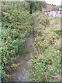
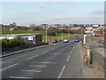
Bridge over Farnley Wood Beck, Old Road, Churwell
"Old Road" has probably borne that name since the Leeds to Elland turnpike road (still called Elland Road) was built in 1815.
Image: © Stephen Craven
Taken: 21 Jul 2020
0.01 miles
4
Milestone, Elland Road, Churwell
This is in a poor state, but still intact. It is no longer shown on OS maps.
Image: © Humphrey Bolton
Taken: 16 Mar 2010
0.03 miles
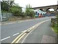
5
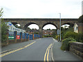
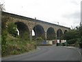
Churwell railway viaduct
The viaduct, along with other viaducts and bridges on the South Trans-Pennine main line (Leeds to Manchester), was listed grade II (List entry 1451053) as recently as 2018, in advance of projected upgrade works to the route. Reasons for listing were as "a little altered example of an 1840s viaduct on what is now one of the main railway lines in northern England" and that it was designed by the notable Scottish railway engineer Thomas Grainger.
Image: © Stephen Craven
Taken: 21 Jul 2020
0.03 miles
6
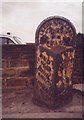
Old Milestone by the A643, Elland Road, Churwell
Milestone by the A643, in parish of Morley (Leeds District), Elland Road, Churwell, just North of railway bridge (Six arches viaduct), on very narrow verge between wall and kerb, South East side of road.
Inscription reads:-
: MORLEY / 1½ MILES / BIRSTALL / 4 MILES / CLECKHEATON / 6½ MILES : : LEEDS & ELLAND / ROAD / MORLEY : : LEEDS / 3 MILES :
Grade II listed.
List Entry Number: 1135106 https://historicengland.org.uk/listing/the-list/list-entry/1135106
Milestone Society National ID: YW_LEEL03
Image: © Milestone Society
Taken: Unknown
0.04 miles
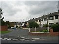
9
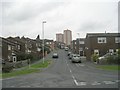
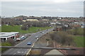
Cottingley Approach - Cottingley Drive
Image: © Betty Longbottom
Taken: 21 Sep 2009
0.06 miles