IMAGES TAKEN NEAR TO
St. Andrews Terrace, LEEDS, LS27 0QQ
Introduction
This page details the photographs taken nearby to St. Andrews Terrace, LS27 0QQ by members of the Geograph project.
The Geograph project started in 2005 with the aim of publishing, organising and preserving representative images for every square kilometre of Great Britain, Ireland and the Isle of Man.

There are currently over 7.5m images from over14,400 individuals and you can help contribute to the project by visiting https://www.geograph.org.uk
Image Map (Loading...)


Getting Data...Please wait
Leaflet Map data © OpenStreetMap
Images are licensed for reuse under creativecommons.org/licenses/by-sa/2.0
Notes
- Clicking on the map will re-center to the selected point.
- The higher the marker number, the further away the image location is from the centre of the postcode.
Image Listing (127 Images Found)
Images are licensed for reuse under creativecommons.org/licenses/by-sa/2.0
Image
Details
Distance
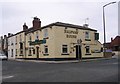
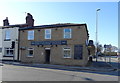
1

The Halfway House
Bruntcliffe Road, near Morley.
Image: © Steve Fareham
Taken: 10 Mar 2009
0.02 miles
3
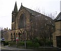
Church - Fountain Street
Now converted into flats.
Image: © Betty Longbottom
Taken: 26 Jan 2008
0.03 miles
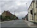
4
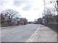
Bruntcliffe Road - viewed from Ashfield Road
Image: © Betty Longbottom
Taken: 16 Apr 2012
0.04 miles
5
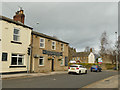
The Halfway House, Scotchman Lane, Morley
At the junction with the A650 which at this point changes name from Britannia Road to Bruntcliffe Road; it is probably intended to be halfway between Bradford and Wakefield.
Image: © Stephen Craven
Taken: 11 Jan 2020
0.04 miles
8
Junction with Scotchman Lane and the A650 Morley
Image: © Steve Fareham
Taken: 28 Feb 2012
0.05 miles
9
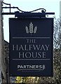
Sign for the Halfway House, Morley
See Image] for context.
Image: © JThomas
Taken: 27 Feb 2020
0.05 miles
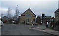
10
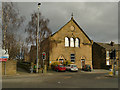
Converted chapel, Morley
Alongside the A650 which at this point changes name from Britannia Road to Bruntcliffe Road. It has been converted to housing for at least ten years, see Image There was a Methodist chapel close by, and an Anglican church (St Andrew's) still exists, so I don't know what denomination this was.
Image: © Stephen Craven
Taken: 11 Jan 2020
0.06 miles