IMAGES TAKEN NEAR TO
St. Andrews Close, LEEDS, LS27 0JY
Introduction
This page details the photographs taken nearby to St. Andrews Close, LS27 0JY by members of the Geograph project.
The Geograph project started in 2005 with the aim of publishing, organising and preserving representative images for every square kilometre of Great Britain, Ireland and the Isle of Man.

There are currently over 7.5m images from over14,400 individuals and you can help contribute to the project by visiting https://www.geograph.org.uk
Image Map (Loading...)


Getting Data...Please wait
Leaflet Map data © OpenStreetMap
Images are licensed for reuse under creativecommons.org/licenses/by-sa/2.0
Notes
- Clicking on the map will re-center to the selected point.
- The higher the marker number, the further away the image location is from the centre of the postcode.
Image Listing (132 Images Found)
Images are licensed for reuse under creativecommons.org/licenses/by-sa/2.0
Image
Details
Distance
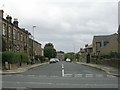
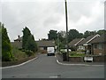
1
St Andrew's Avenue - Bruntcliffe Road
Image: © Betty Longbottom
Taken: 15 Sep 2009
0.03 miles
2
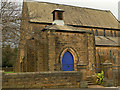
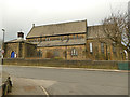
St Andrew's church, Bruntcliffe, Morley - porch
The south-west porch is unusually substantial compared with the church building as a whole. It may have been intended as the base for a tower that was never completed. For context, see Image
Image: © Stephen Craven
Taken: 11 Jan 2020
0.04 miles
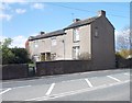
3
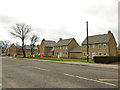
Perry Way Estate, Morley (5)
Other photos of this new estate to the south of Bruntcliffe Road are in square Image
Image: © Stephen Craven
Taken: 11 Jan 2020
0.04 miles
4
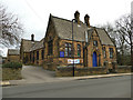
St Andrew's church, Bruntcliffe, Morley - south side
The (liturgical) south side of the road facing St Andrew's Avenue. St Andrew’s is an Anglican church, built on land donated by Lord Dartmouth (after whom the nearby park is also named) and consecrated in 1891 by the Bishop of Wakefield. It is not listed. It now forms part of the Morley Team Ministry in the Diocese and Archdeaconry of Leeds.
Image: © Stephen Craven
Taken: 11 Jan 2020
0.04 miles
5
Street Farm House - Bruntcliffe Road
Image: © Betty Longbottom
Taken: 16 Apr 2012
0.04 miles
6
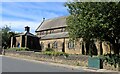
St Andrew's community hall, Bruntcliffe, Morley
Immediately to the north-east of the church building Image and originally opened as a Sunday School in 1895, four years after the church itself.
Image: © Stephen Craven
Taken: 11 Jan 2020
0.04 miles
7
St Andrew's Church, Bruntcliffe
Anglican church consecrated in 1891, located in Bruntcliffe, Morley.
Image: © Chris Heaton
Taken: 3 Sep 2024
0.04 miles
8
St Andrew's Close - St Andrew's Avenue
Image: © Betty Longbottom
Taken: 15 Sep 2009
0.04 miles
9
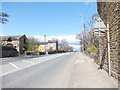
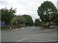
Bruntcliffe Road - viewed from Ashfield Road
Image: © Betty Longbottom
Taken: 16 Apr 2012
0.04 miles