IMAGES TAKEN NEAR TO
Millington Road, LEEDS, LS27 0GG
Introduction
This page details the photographs taken nearby to Millington Road, LS27 0GG by members of the Geograph project.
The Geograph project started in 2005 with the aim of publishing, organising and preserving representative images for every square kilometre of Great Britain, Ireland and the Isle of Man.

There are currently over 7.5m images from over14,400 individuals and you can help contribute to the project by visiting https://www.geograph.org.uk
Image Map
Images are licensed for reuse under creativecommons.org/licenses/by-sa/2.0
Notes
- Clicking on the map will re-center to the selected point.
- The higher the marker number, the further away the image location is from the centre of the postcode.
Image Listing (76 Images Found)
Images are licensed for reuse under creativecommons.org/licenses/by-sa/2.0
Image
Details
Distance
1
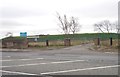
Covered Reservoir - Bruntcliffe Road
Image: © Betty Longbottom
Taken: 28 Nov 2011
0.04 miles
2
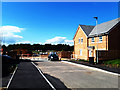
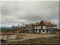
Next phase of development beyond St Andrew's Place
Even before the final road surface had been laid on the first phase of development, work had started on the second phase.
Image: © Stephen Craven
Taken: 1 Sep 2020
0.05 miles
3
Morley service reservoir
Also known as Victoria reservoir, this is a large covered water storage reservoir at roughly the highest point of the town. Originally this was supplied directly from the impounding reservoir at Withens Clough near Hebden Bridge, along a 15" main ("designed by engineer Charles Gott to make use of the difference in altitude, with Withens at 1000ft to Morley's 400ft, to send up to 1.5 million gallons of water a day along a twenty one mile pipe to Morley") with treatment restricted to liming for pH correction. Nowadays the water is, as far I can recall from my work with Yorkshire Water in the 1990s, treated at the Fixby works above Elland before being forwarded to Morley and other service reservoirs. See also Image
Image: © Stephen Craven
Taken: 11 Jan 2020
0.05 miles
4
Morley Victoria Service Reservoir - Bruntcliffe Road
Image: © Betty Longbottom
Taken: 16 Apr 2012
0.06 miles
5
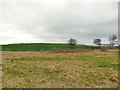
Perry Way estate, Morley (3)
The second phase now under construction.
Image: © Stephen Craven
Taken: 11 Jan 2020
0.06 miles
6
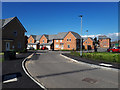
St Andrew's Place, Bruntcliffe
A new housing development off Bruntcliffe Road, named after a nearby church Image Many of these houses were already occupied, presumably having been bought "off plan".
Image: © Stephen Craven
Taken: 1 Sep 2020
0.06 miles
7
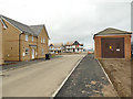
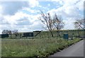
Perry Way estate, Morley (2)
Looking from the first phase of this new estate towards the second phase now under construction. Note the electricity substation included as part of the infrastructure.
Image: © Stephen Craven
Taken: 11 Jan 2020
0.07 miles
8
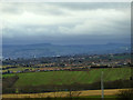
Perry Way estate, Morley - view to Deer Hill
This new housing estate built on the site of the former Street Farm is at virtually the highest point of the town, and offers surprising views to the south and west - looking here towards Deer Hill and Pule Hill above Marsden.
Image: © Stephen Craven
Taken: 11 Jan 2020
0.07 miles
9
Perry Way estate, Morley - view to Castle Hill
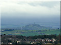
This new housing estate built on the site of the former Street Farm is at virtually the highest point of the town, and offers surprising views to the south and west - looking here towards Castle Hill above Huddersfield.
Image: © Stephen Craven
Taken: 11 Jan 2020
0.07 miles
10
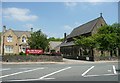
St Andrew's Church, Bruntcliffe Road, Morley
The former vicarage is now a hotel.
Image: © Humphrey Bolton
Taken: 3 Jun 2010
0.07 miles