IMAGES TAKEN NEAR TO
Greenfield Terrace, LEEDS, LS26 9JR
Introduction
This page details the photographs taken nearby to Greenfield Terrace, LS26 9JR by members of the Geograph project.
The Geograph project started in 2005 with the aim of publishing, organising and preserving representative images for every square kilometre of Great Britain, Ireland and the Isle of Man.

There are currently over 7.5m images from over14,400 individuals and you can help contribute to the project by visiting https://www.geograph.org.uk
Image Map (Loading...)


Getting Data...Please wait
Leaflet Map data © OpenStreetMap
Images are licensed for reuse under creativecommons.org/licenses/by-sa/2.0
Notes
- Clicking on the map will re-center to the selected point.
- The higher the marker number, the further away the image location is from the centre of the postcode.
Image Listing (15 Images Found)
Images are licensed for reuse under creativecommons.org/licenses/by-sa/2.0
Image
Details
Distance
5
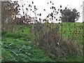
A large clump of teasels
Teasels were once a commercial crop in West Yorkshire. They were used to 'card' wool fibres, before they were spun.
Image: © Christine Johnstone
Taken: 20 Nov 2009
0.08 miles
7
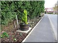
Flowers at Lower Mickletown
Someone has kindly turned a narrow verge into a communal garden.
Image: © Christine Johnstone
Taken: 20 Nov 2009
0.10 miles
8
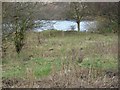
Large pond in the flood plain of the River Aire
Image: © Christine Johnstone
Taken: 20 Nov 2009
0.18 miles
9
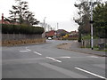
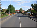
Lower Mickletown - viewed from Pinfold Lane
Image: © Betty Longbottom
Taken: 1 Apr 2016
0.20 miles