IMAGES TAKEN NEAR TO
Burnleys Court, LEEDS, LS26 9BP
Introduction
This page details the photographs taken nearby to Burnleys Court, LS26 9BP by members of the Geograph project.
The Geograph project started in 2005 with the aim of publishing, organising and preserving representative images for every square kilometre of Great Britain, Ireland and the Isle of Man.

There are currently over 7.5m images from over14,400 individuals and you can help contribute to the project by visiting https://www.geograph.org.uk
Image Map (Loading...)


Getting Data...Please wait
Leaflet Map data © OpenStreetMap
Images are licensed for reuse under creativecommons.org/licenses/by-sa/2.0
Notes
- Clicking on the map will re-center to the selected point.
- The higher the marker number, the further away the image location is from the centre of the postcode.
Image Listing (44 Images Found)
Images are licensed for reuse under creativecommons.org/licenses/by-sa/2.0
Image
Details
Distance
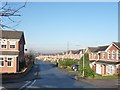
1
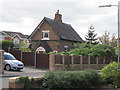
Methley Junction railway station (site), Yorkshire
Opened in 1860 by the Lancashire & Yorkshire Railway on its line from Methley North to Castleford Cutsyke, this station closed to passengers in 1943.
It was one of a trio of stations to serve Methley. Now there are none, and this building is situated in the middle of a housing estate. The line used to run roughly where the road now is.
Image: © Nigel Thompson
Taken: 19 May 2013
0.03 miles
2
Hallam line train approaching Methley Junction
The 1518 Nottingham to Leeds (1Y22) formed of 195018 approaches Methley Junction and is viewed from the former Lofthouse to Methley railway line which would have also joined the junction.
Image: © DS Pugh
Taken: 20 Apr 2024
0.05 miles
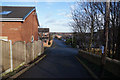
4
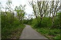
Cycle path near Methley Junction
The Castleford Greenway runs along the former Lofthouse to Methley railway line.
Image: © DS Pugh
Taken: 20 Apr 2024
0.06 miles
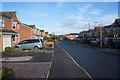
5
Green Row, Methley Junction
Looking down from the disused railway bridge towards Barnsdale Road.
Image: © Christine Johnstone
Taken: 16 Nov 2010
0.07 miles
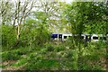
6
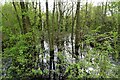
Flooded woods at Methley Junction
The Castleford Greenway runs along the former Lofthouse to Methley railway line.
Image: © DS Pugh
Taken: 20 Apr 2024
0.07 miles
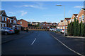
9
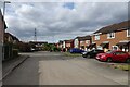
Pinders Green Walk
The street connects to the Castleford Greenway which runs along the former Lofthouse to Methley railway line.
Image: © DS Pugh
Taken: 20 Apr 2024
0.08 miles
10
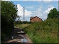
First and last house
Taken from the track alongside the railway.
Image: © Christine Johnstone
Taken: 14 Aug 2010
0.09 miles